
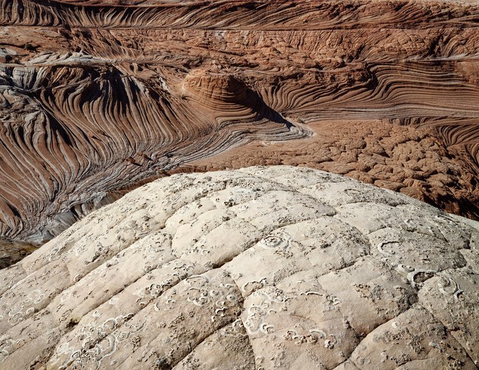
Two hundred million years ago, along what is now the border between Utah and Arizona, enormous dunes shaped by shifting winds migrated across a landscape dotted with oases that provided water and food for several types of three-toed dinosaurs. These cross-bedded dunes solidified into the Jurassic Navajo Sandstone and, after being uplifted a mile by tectonic forces, have since eroded into the striking landforms of Coyote Buttes.
Over a thousand dinosaur tracks are imprinted in the rock, overrun by the sandy footprints of hikers exploring this exotic environment filled with bewildering formations. In the late 1980s, a friend at Utah’s Canyonlands Field Institute suggested I visit the buttes to discover a terrain few knew about—a destination reached by crossing open country near the slot canyons of Buckskin Gulch. At that time, the red rock country was far less explored, with its remote wonders accessible by following deeply rutted four-wheel drive routes, far from major highways.
I was the sole visitor when I first discovered these buttes, though I approached with trepidation as I encountered the fragile sedimentary rock. Time and wind had worn their edges into delicate fins that could barely withstand being touched, let alone hiked on or climbed over. Swirling ribbons of color, formed by the oxidation of minerals like iron and manganese into thin, striped bands, began to attract attention. Published photographs started showcasing this landscape’s surreal beauty, drawing in more visitors. To help mitigate the danger of irreparable damage to the brittle formations, today, visitors apply for a limited number of daily hiking permits and are asked to follow hiking protocols.