
In 1868, while leading a government geological expedition in southwestern Idaho, Clarence King remarked upon first beholding Shoshone Falls: "You ride upon a waste. Suddenly, you stand upon a brink. Black walls flank the abyss. A great river fights its way through the labyrinth of blackened ruins and plunges in foaming whiteness. Nor does the flashing whiteness brighten the aspect. In contrast with its brilliancy, the rocks seem darker and more wild."
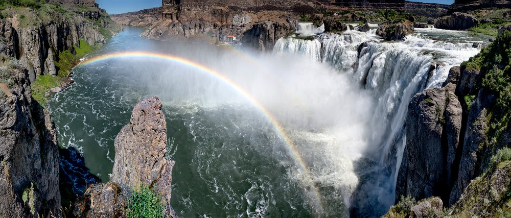
Plunging 212 feet, the falls formed approximately 14,000 years ago from a cataclysmic flood originating from Lake Bonneville, which once occupied the same basin as today’s much smaller Great Salt Lake. The flood carved through southern Idaho's volcanic landscape within weeks, shaping the Snake River Canyon. The floodwaters struck a hardened layer of pink-gray rhyolite, resulting in a natural dike that created the falls. Located one thousand river miles from the Pacific, it once marked the limit of migrating salmon and the fishing grounds for the Shoshone ("salmon eating") people before the construction of downstream dams.
The river, which originates on the western side of Yellowstone and Grand Teton National Parks, flowed at a robust 14,000 cubic feet per second on the day this photograph was taken, showcasing a cascading sweep of water typical for early June. On the opposite side of the river from this overlook, a dam situated just above the falls diverts some of the river’s water to a hydroelectric plant at the base of the falls. Every year, as the summer growing season progresses, upstream diversions for crop irrigation reduce the flow to a mere trickle between the gaps in the cliffs.