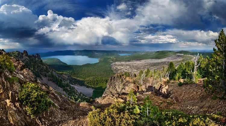
Standing on the summit of Paulina Peak, the first thing that caught my eye was the approaching storm. Soon, rain and hail hammered the cindered ground, and briefly, the wind picked up; lightning flashed, and thunder echoed off the canyon walls. The storm moved north over Paulina and East Lakes before heading into the high desert surrounding this ancient crater.
At an elevation of 8,000 feet, Paulina Peak is the highest point along the rim surrounding the collapsed Newberry Volcano, which formed the caldera shown in this photograph. The peak offers a 360-degree view spanning hundreds of miles in all directions, from Mt. Adams in Washington State to California's Mt. Shasta.
About half a million years ago, the volcano's 14,000-foot summit was roughly in the center of the photograph, above the lakes and the forest basin of lodgepole and ponderosa pine. Today, resting on a thin layer of the Earth’s crust, the caldera remains volcanically active, with several monitoring stations recording ground vibrations and changes in the shape and movement of the terrain in real-time.
To the right lies a tan-gray obsidian field, the most recent geologic addition to the basin. Lava flowed from the rim adjacent to Paulina Peak 1300 years ago and then cooled into volcanic glass. The obsidian boulders are so sharp along their edges that native tribes chipped arrowheads from them. The crater was initially visited by hunter-gatherer peoples beginning at least 11,000 years ago, not long after the Ice Age ended. Today, the caldera is a land of lakes and forests, a place to camp, hike, and fish.

