
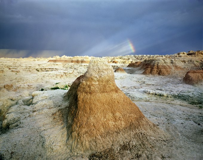
When I first drove into the badlands, I left behind the Midwest's verdant plains to unexpectedly arrive in a haunting land of crumbling clay. As I explored, I began to realize its extraordinary and surreal barrenness was changing my way of perceiving it. That afternoon, a thunderstorm had formed over the Black Hills and moved east across this desolate country. The horizon was notched by pinnacles and buttes upon ground broken by ravines and escarpments. Above spun a cinematic firmament filled with flashes of lightning, fleeting shards of light, storm clouds with trailing sheets of rain, and a splintered rainbow.
Labeled "bad lands" by the Lakota people, 18th-century trappers and 19th-century wagon trains avoided crossing this part of western South Dakota. This rugged geography marks a break between the low-lying Prairie Plains that begin west of the Mississippi River and the elevated High Plains that skirt the eastern perimeter of the Black Hills and the Rockies.
Seventy-five million years ago, these mountains began forming as the western part of North America rose. Buried layers of lithified mud were uplifted from a sea that divided the continent. The soft mudstone crumbled and turned to clay, forming the badlands' "Yellow Mounds" in this photograph. Later, remnants of tropical forests, savannah grasslands, wildlife, and volcanic ash from distant eruptions added their sedimentary layers. Today, the terrain's relief looks like a three-dimensional geologic map illustrating a history that, 500,000 years from now, will be entirely washed away.
- James Baker