
Weekly Insights
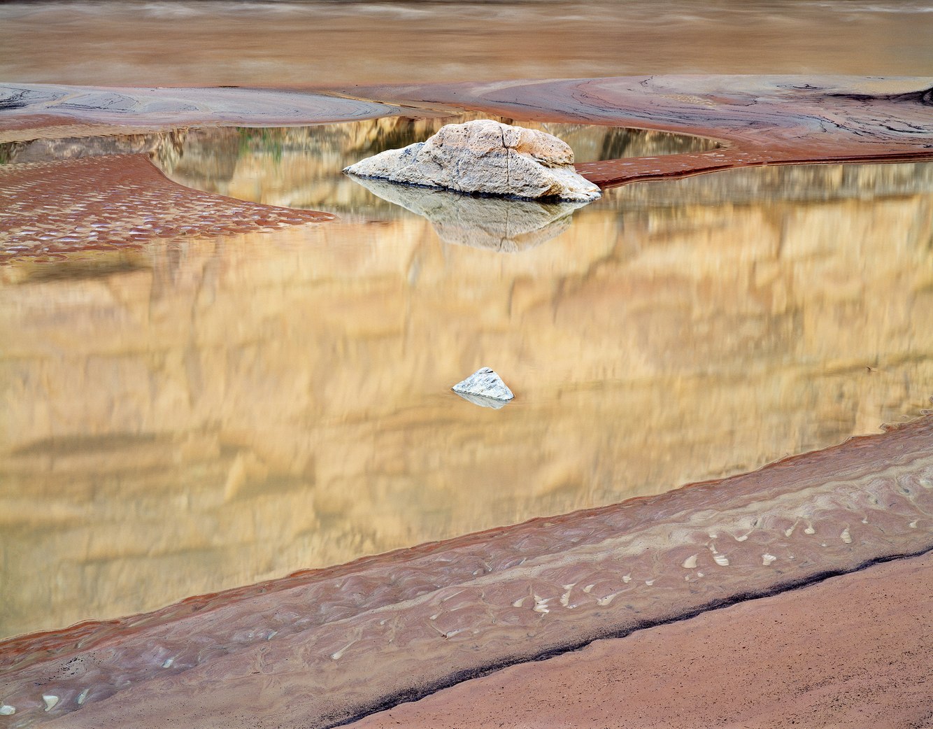
John's Canyon, San Juan River, Utah
On this quiet morning, the mudflats where John's Canyon meets the San Juan River displayed a fresh layer of sediment as a flood from the previous day abated. A radiant stone and stippled boulder – having long ago tumbled out of the canyon's mouth – rested in an elliptical pool. Its tranquil water luminously mirrored the pre-dawn light reflecting off an 800-foot-tall cliff. The scene struck me as a dreamlike set piece.
Southeastern Utah...
more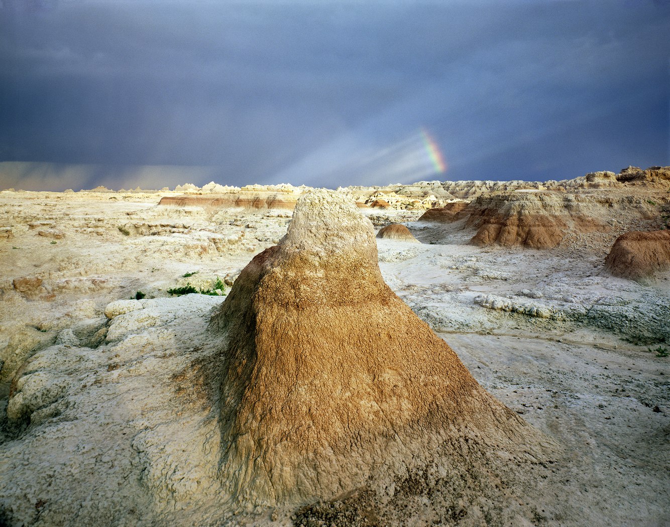
Badlands National Park, near Interior, South Dakota
When I first drove into the badlands, I left behind the Midwest's verdant plains to unexpectedly arrive in a haunting land of crumbling clay. As I explored, I began to realize its extraordinary and surreal barrenness was changing my way of perceiving it. That afternoon, a thunderstorm had formed over the Black Hills and moved east across this desolate country. The horizon was notched by pinnacles and buttes upon ground broken by ravines and...
more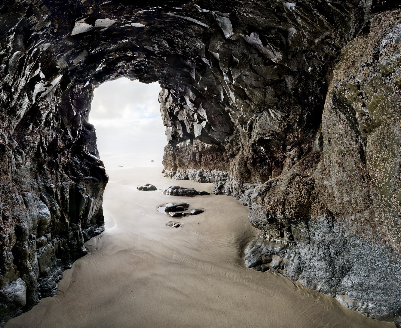
Sea Cave, Cape Lookout Beach, Oregon
Where the sea meets the beach, waves funneled into this cave. During the brief lull between waves, I entered to understand what a sea cave looks and feels like when the ocean rushes into it. A surging swell raised the water level; waves rinsed the layer of barnacles attached to the lava walls. Through the cacophony of countless air bubbles bursting, the waves gave voice to their journey's end. As the tide retreated, my footprints were erased,...
more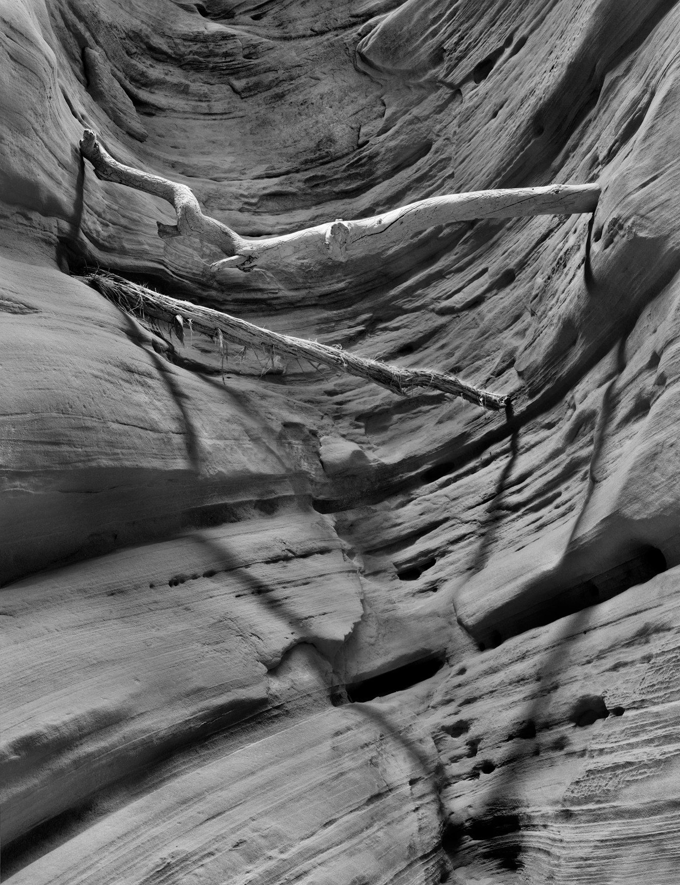
Branches from Flash Flood, Buckskin Gulch, Arizona
Buckskin Gulch is a classic slot canyon: long, narrow, deep, visually stunning, and unnervingly claustrophobic. It traverses the rugged desert country bordering Utah and Arizona, part of a broader region of uplifted red rock called the Colorado Plateau. The upraised sandstone fractured, forming joints that periodic flash floods carved to create extraordinarily narrow chasms.
I made this photograph near the beginning of the gulch, where...
more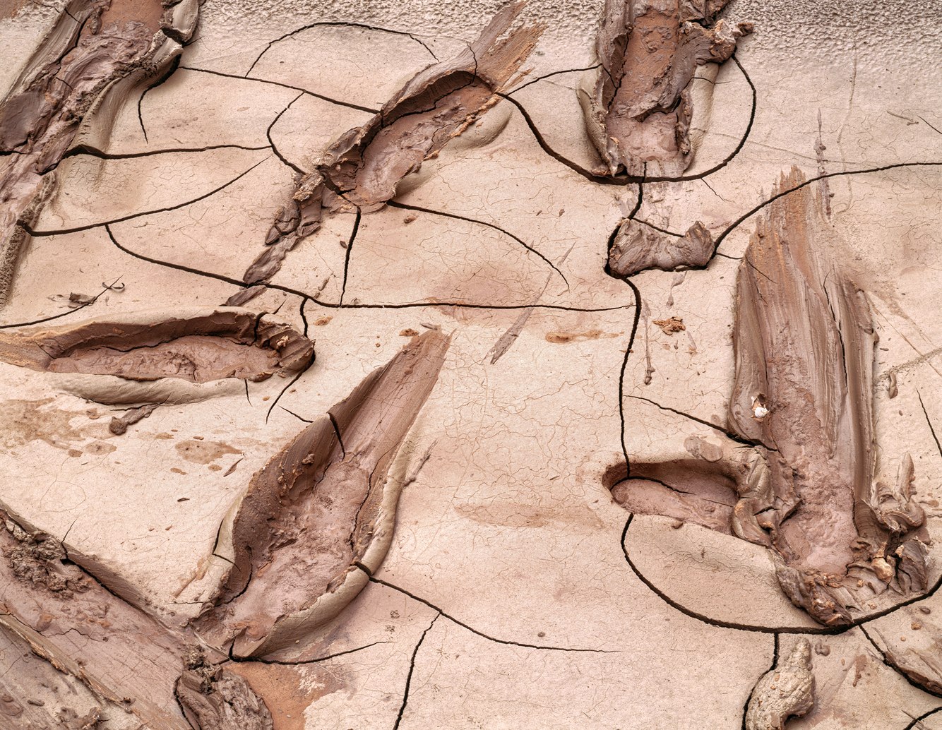
Tracks, Drying Mud, San Juan River, Utah
As we rafted down southern Utah's San Juan River, we saw that a flash flood had raced down the river ahead of us, originating from one of its side canyons after a late summer storm. Once the river receded and the silty flow settled out along the riverbanks at the entrance to Oljeto Canyon, the desert air began hardening the fresh blanket of mud.
As we exited the river boats, mud stuck to our sandals and squirted around our feet,...
more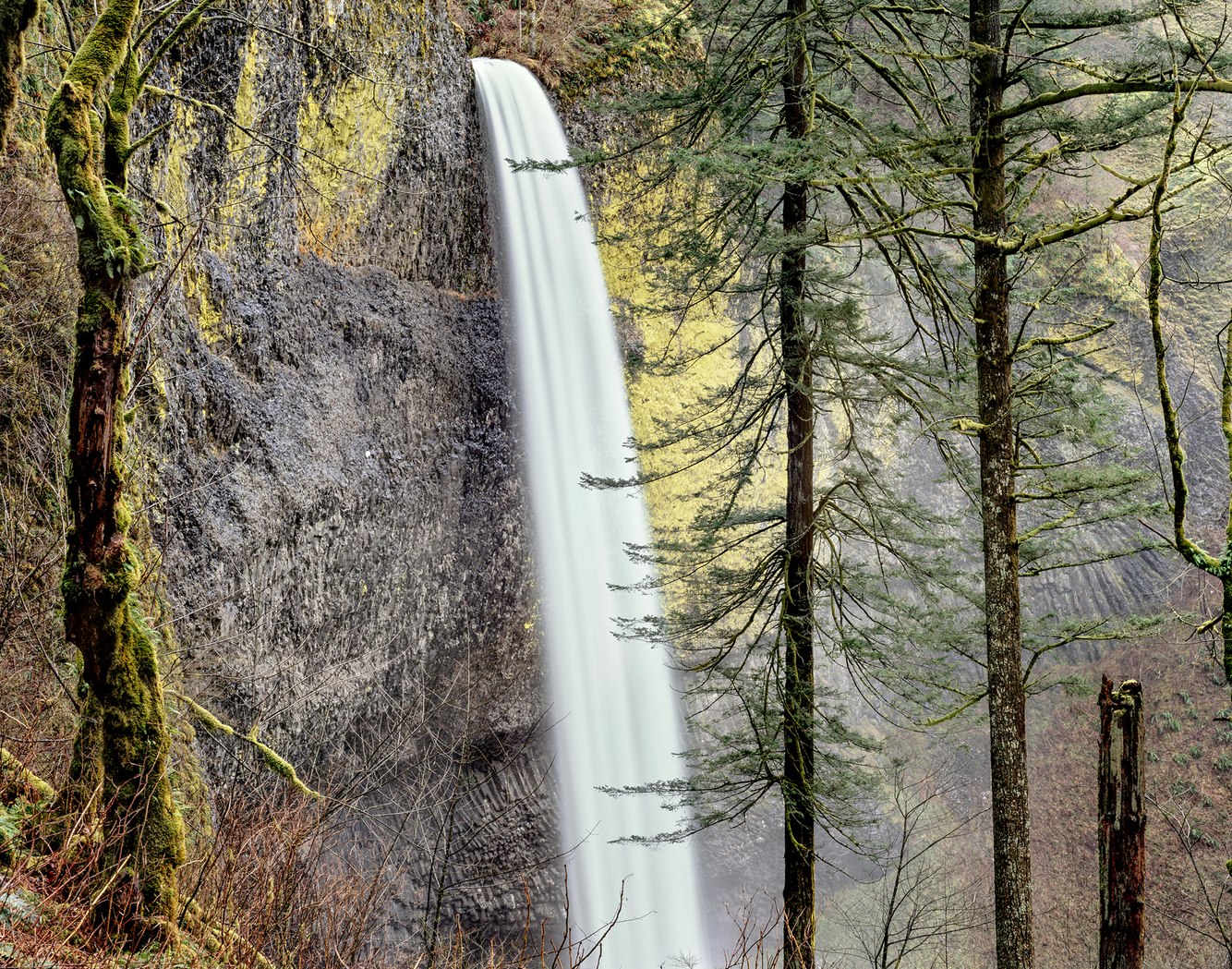
Latourell Falls, Upper View, Columbia River Gorge, Oregon
The Columbia River Gorge marks the boundary between western Washington State and Oregon. A fjord-like 80-mile stretch of river is inhabited by 90 waterfalls. Almost all of them are on the Oregon side, where the topography favors their formation. Over millions of years, hundreds of lava flows built layers of basalt rock that tilted away from the river to form the sheer cliffs, over which the water descended.
Latourell Falls is the...
more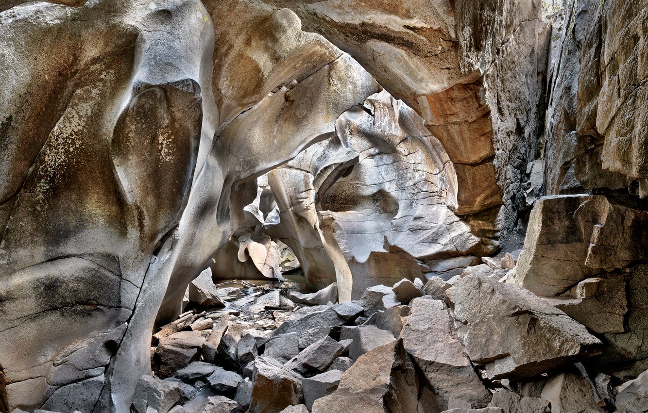
Grottos Cave, near Aspen, Colorado
Grotto is a term often used to describe a natural cave or cavern, though the word derives from something human-made. A richly decorated structure built by the Roman Emperor Nero soon after the burning of Rome in 64 A.D. had, over time, sunk underground only to be rediscovered in the 15th century. Upon viewing, it was considered very strange; something uncovered from the “underworld” and was called a grottesca – literally “of a cave.”...
more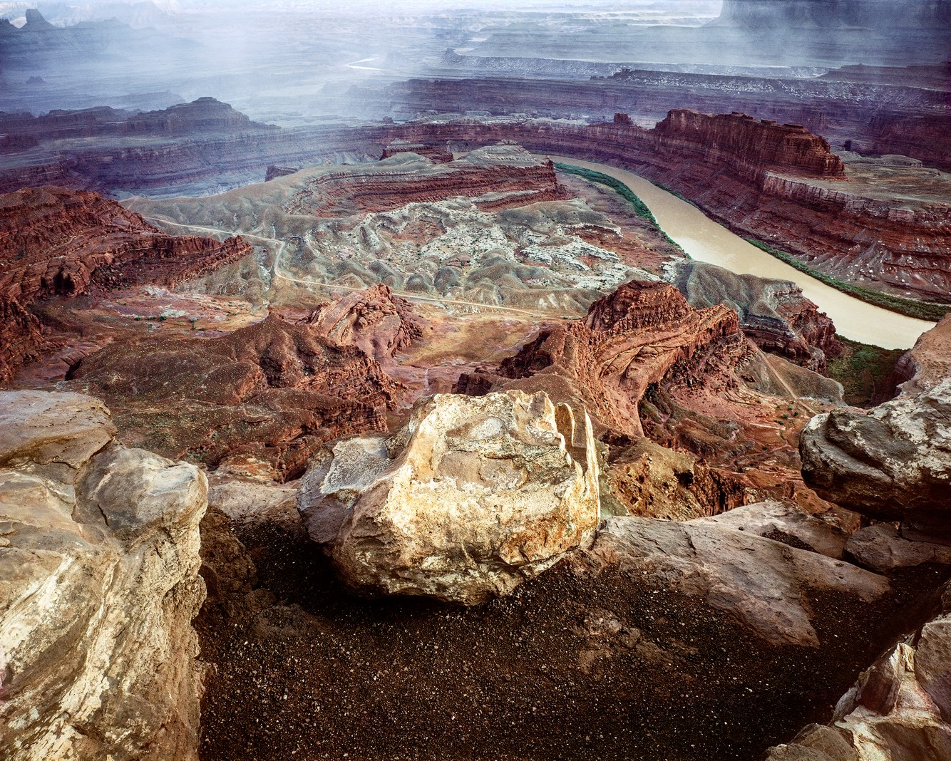
Colorado River Overlook, Dead Horse Point, Utah
Standing at the edge of eastern Utah's Dead Horse Point, I survey a 270-degree view east, south, and west across the grand expanse of red rock country and down 2000 feet through geologic time, and the lithified layers of mud and sand from an ancient era, when the North American continent was located near the equator.
Over eons, these sedimentary stratums were deposited in oceans, windblown deserts, freshwater lakes, streams, and...
more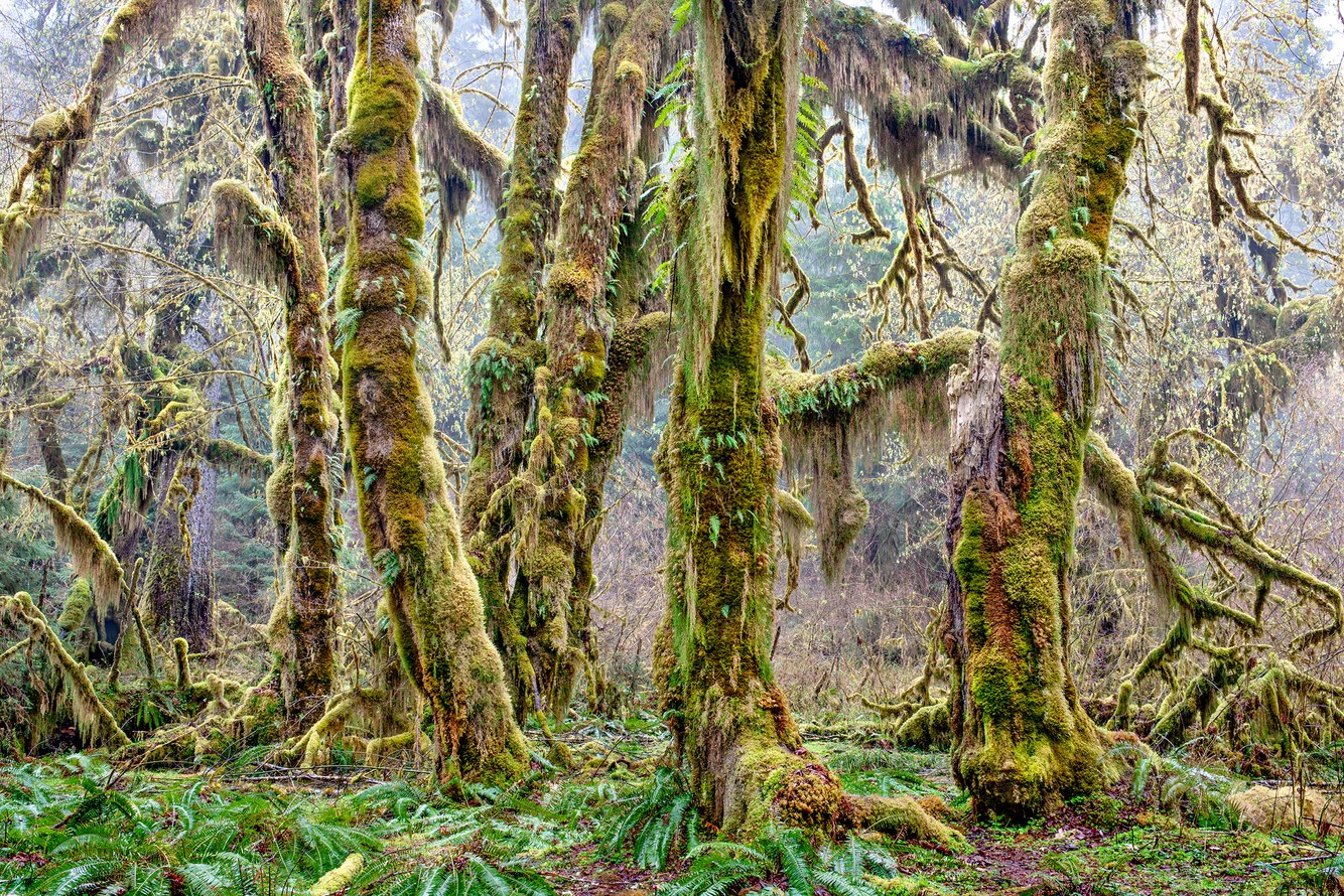
Hall of Mosses, Hoh Rainforest, Olympic Peninsula, Washington
Amid Washington State's Olympic Mountain Range, the Hoh Rainforest shelters ancient stands of coniferous and deciduous trees, most notably along its Hall of Mosses Trail. One of the best-preserved temperate rainforests in the world, its stable ecosystem is maintained by a steady flow of moist air off the Pacific Ocean. It delivers abundant rainfall of twelve feet annually in the cooler seasons and ample sunshine in the drier summer.
It...
more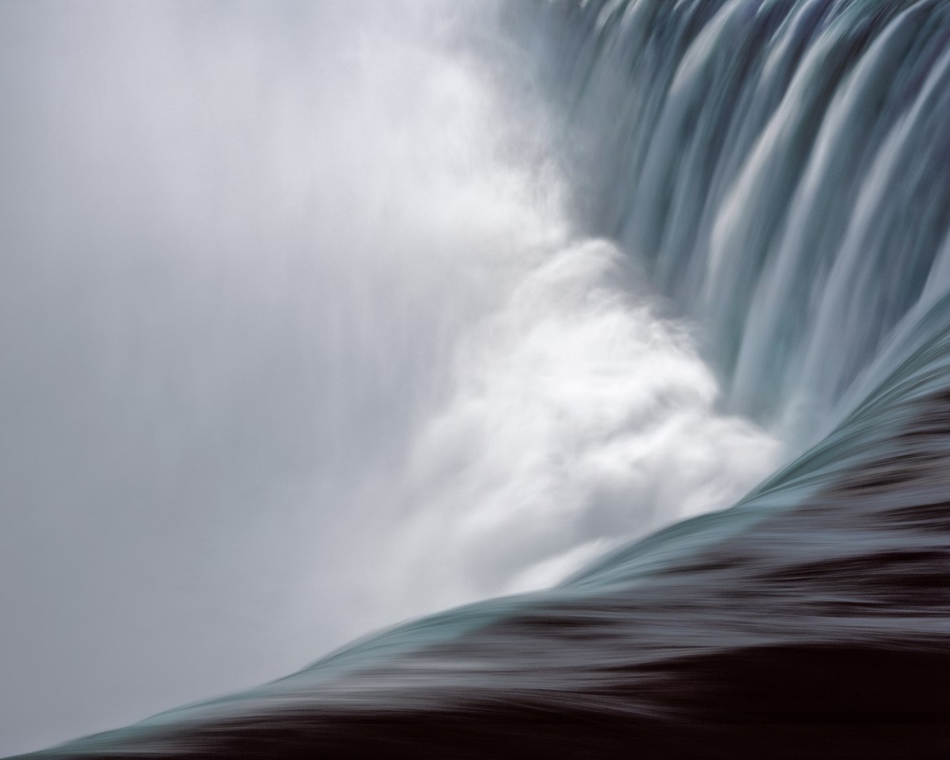
Horseshoe Falls, Niagara River, Ontario
Horseshoe Falls is the largest of the three waterfalls forming Niagara Falls along the Canada–United States border. Ninety percent of the Niagara River, or an average of 3000 tons of water per second, flows over the 167-foot height and the half-mile-long arc of Horseshoe Falls.
Niagara Falls was created when the Niagara Escarpment was exposed after the retreat of glaciers at the end of the last ice age. The escarpment is a cliff face...
more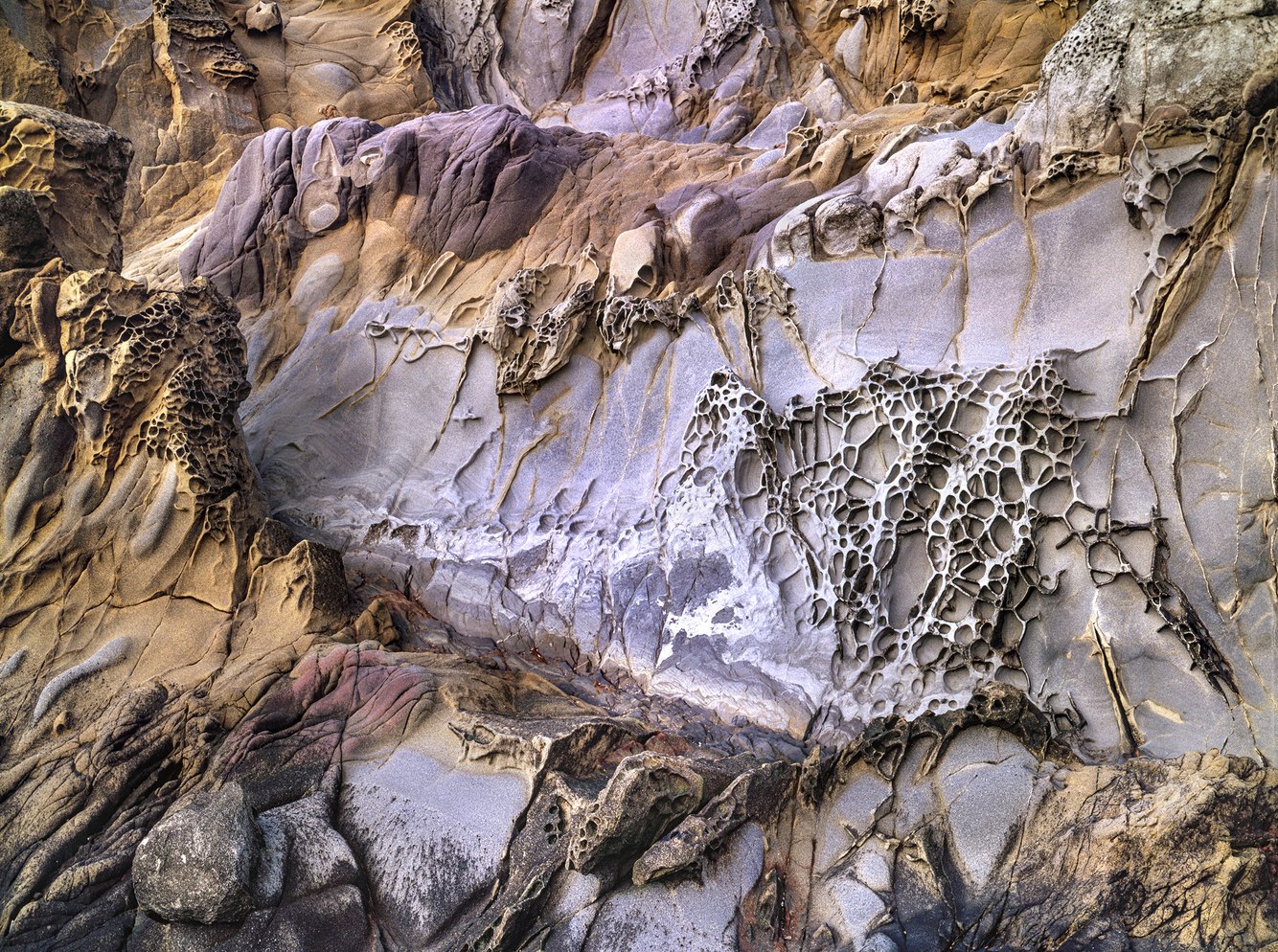
Sandstone Tafoni Formation, Pebble Beach, California
Walking the shoreline of Pebble Beach gave me the opportunity to loiter along the intersection of three states of matter, with the calm Pacific Ocean to my left, the ragged wall of colorful sandstone to my right, and the vaporous sky above. Ambling the shoreline invited a close examination of this extraordinary environment where water, earth, and air converge to craft the landscape’s contours and details, inspiring a state of wonder that left...
more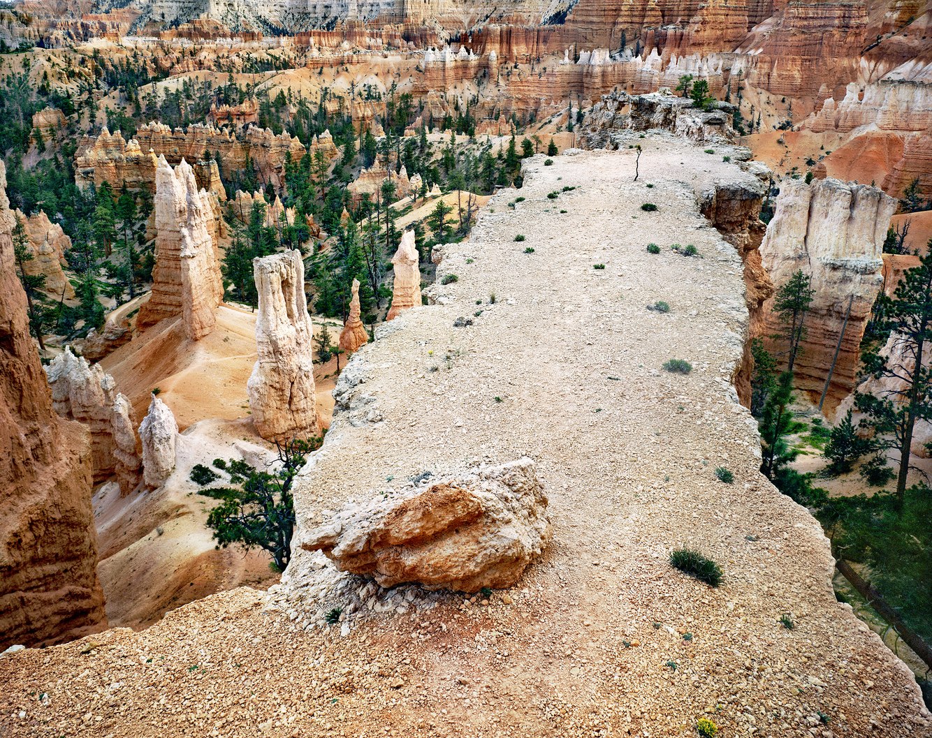
Above the Queen's Garden Trail, Bryce Canyon, Utah
Bryce Canyon is renowned for its colorful, awe-inspiring formations. Their creation began with ancient floods periodically depositing massive amounts of fine-grained sediment over millions of years. Under the weight of its layers, the sediment lithified into rock. The earth's mantle moved and uplifted much of the intermountain west to high plateaus before eroding this part of southwestern Utah to reveal an otherworldly dreamscape.
The...
more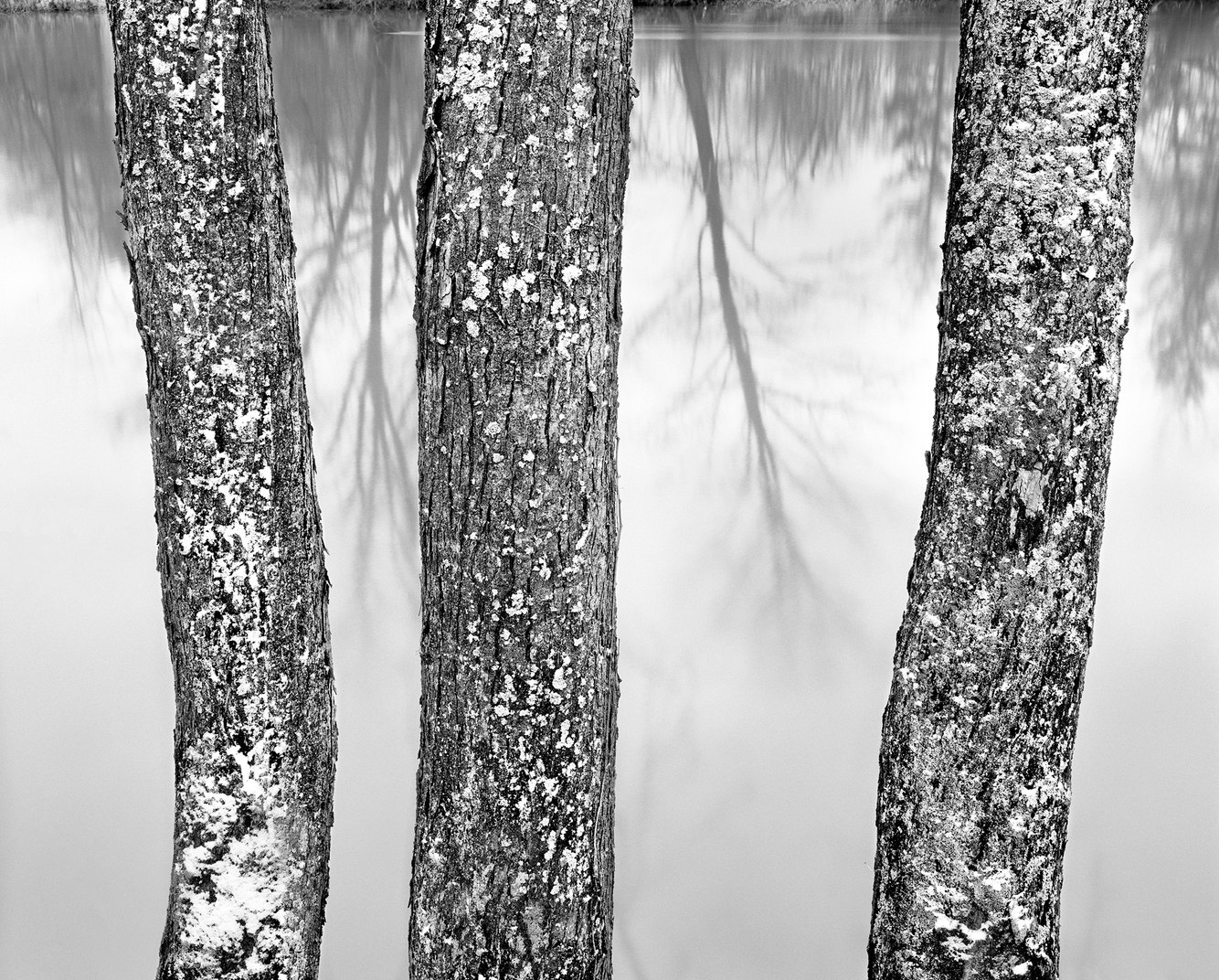
French Creek, near Venango, Pennsylvania
In 1753, George Washington passed by this location, traveling along the Venango Path, an ancient portage trail carved by the Seneca, Onondaga, and Cayuga People and migrating herds of bison. French Creek, named by Washington, marked the western edge of early French and English expansion. In the 19th century, as homesteaders journeyed to the far west, they detoured around this heavily forested region of northwestern Pennsylvania, which...
more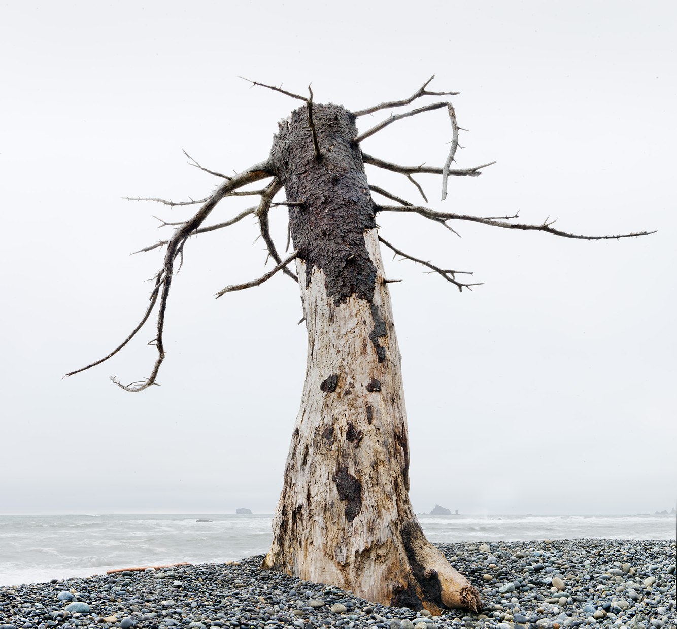
Sitka Tree Snag, Rialto Beach, Olympic Peninsula, Washington
Located along Washington State’s Pacific coast, Rialto Beach is covered by cobblestones and sand relentlessly assaulted by encroaching and sometimes ferocious ocean erosion. Here, a lone Sitka spruce leans into the onshore winds and waves, which have scrapped away at its lower trunk, leaving bark only on the upper part of its leeward side.
Sitka trees grow along a narrow coastal strip from northern California to southern Alaska....
more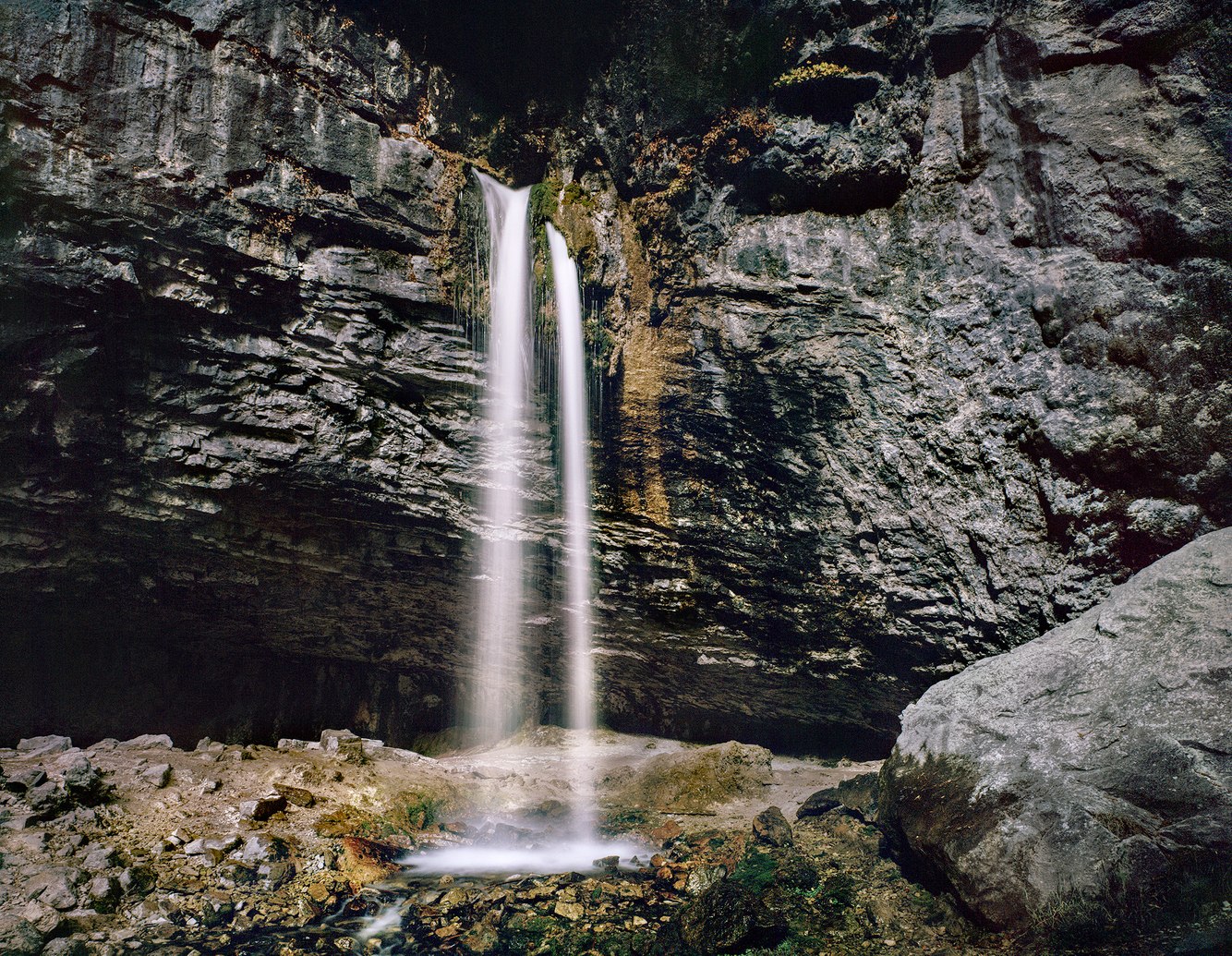
Spouting Rock, Glenwood Canyon, Colorado
Gushing out the cliff's recess, Spouting Rock's unusual waterfall emerges from the sedimentary limestone that underlies this region of central Colorado. The stream then flows into Hanging Lake, situated just below the falls, and, from there, feeds into the nearby Colorado River. The sound of the falls blends the low, rumbling echo of the stream flowing through the crevice's opening and the high-pitched splash of water striking its rocky...
more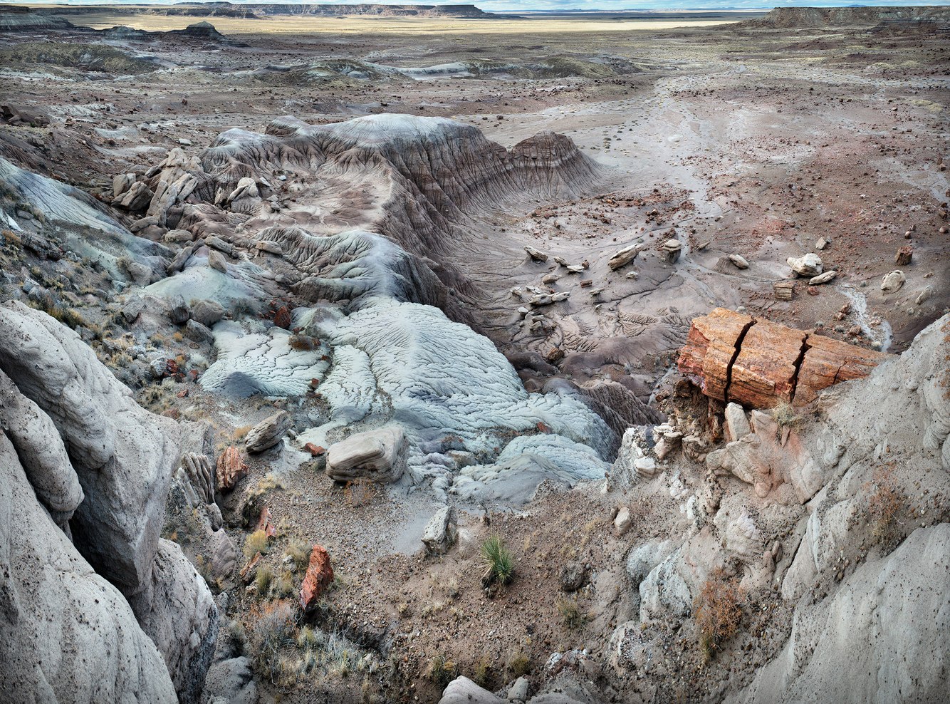
Chinle Formation, Jasper Forest, Petrified Forest National Park, Arizona
Two hundred million years ago, the supercontinent of Pangaea contained the earth's entire landmass. An early variety of pine trees grew along waterways in the region of Pangaea that is now Arizona, where flooding, wind, and death felled whole forests of these 200-foot-tall trees.
'Chinle' means "flowing through." The Navajo Tribe uses this word to describe soils washed down from Arizona's fertile highlands into its otherwise arid...
more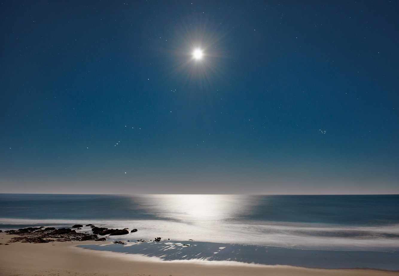
Full Moon, Orion, Lincoln City Beach, Oregon
Orion, the renowned hunter of Greek mythology, was first written about in the 8th century B.C. Though mortal, Orion was reputedly the son of the sea god Poseidon. A fateful story tells of his affection for Artemis, daughter of Zeus and Goddess of the Moon. However, Artemis' jealous twin brother Apollo tricked her into killing Orion. Apollo challenged Artemis – an expert archer – to aim for a head bobbing far out to sea, claiming the swimmer...
more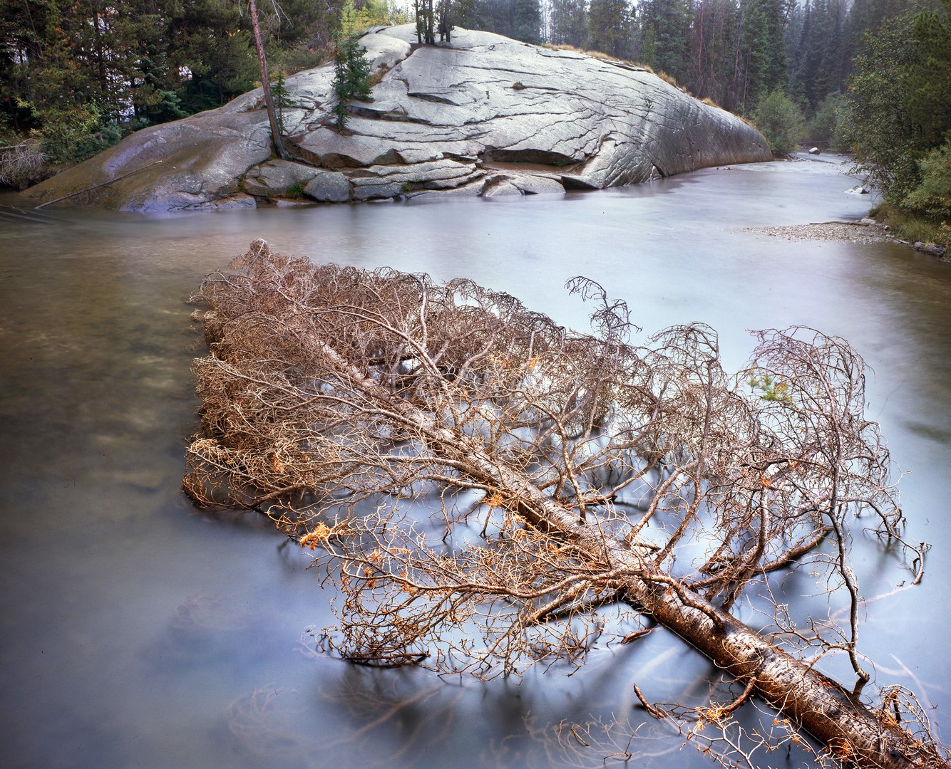
Floating Spruce, Roaring Fork River, Colorado
A young spruce tree falls from the riverbank into a crook in the Roaring Fork River, still green with needles. Over time, I’ve watched its needles brown and thin. Eventually, bark and branches will fall off or be stripped by weather and current. Its trunk will finally settle onto the channel’s stony floor slowly, possibly over many years.
This river originates beneath the nearby crest of the Sawatch Range of central Colorado’s Rocky...
more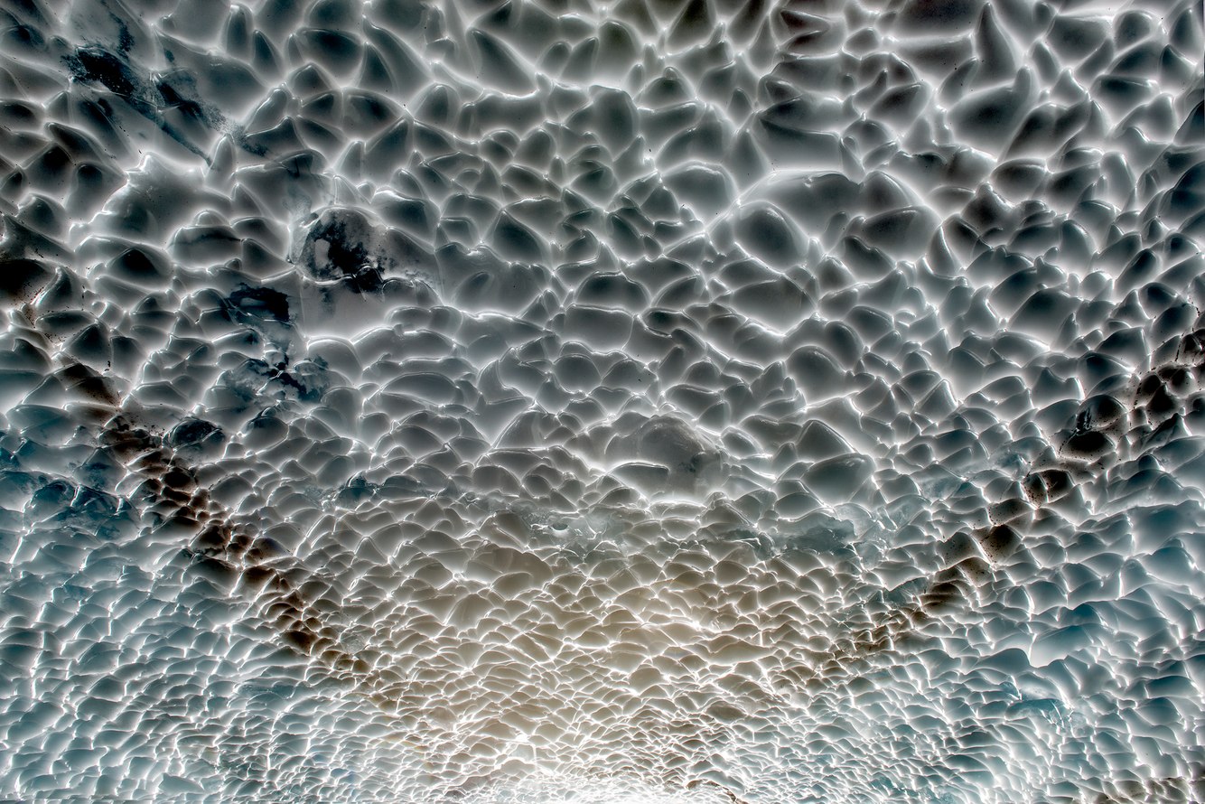
Ceiling, Snow Cave, near Verlot, Washington
Accumulations of deep snow coating Four Mountain – located in western Washington State – cascade down its steep slopes, amassing on a slanted plain at the Mountain's base. This buildup formed a permanent snowfield under which meltwater streams have carved icy, banquet hall-sized caves.
The hike to the caves traverses a terrain littered with the remains of winter's avalanche-downed Pacific Silver Firs (usually found at higher elevations...
more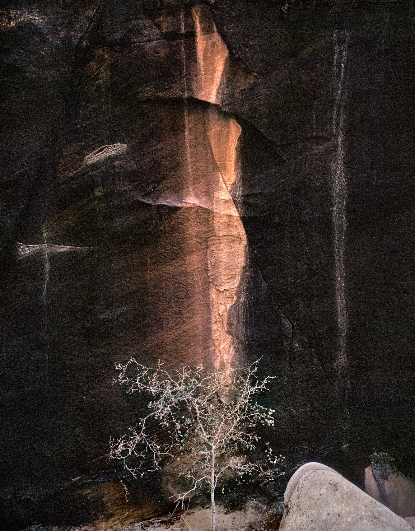
Black Dragon Wash, San Rafael Reef, Utah
Black Dragon Wash takes its name from a nearby pictograph that, as once outlined in chalk, resembled a dragon. Later, it became apparent upon closer inspection that some passersby carelessly encircled what initially appeared to be a dragon but was, in fact, several figures painted in the ancient style of hunter-gatherer tribes from two thousand years ago. Nevertheless, the misnomer became the adopted name of this wilderness canyon within...
more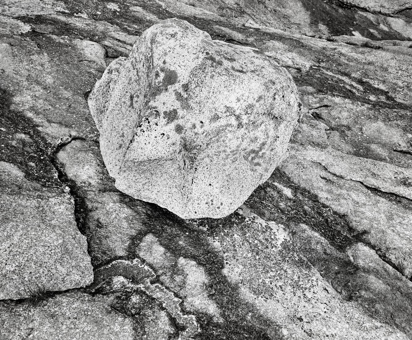
Glacial Erratic, Deer Isle, Maine
A lichen-freckled granite boulder held the evening's fading light. Deposited on a granite bench that rims the shoreline of Deer Isle on Maine's midcoast, it rests uncertainly, transported here by an ancient glacier. When the climate warmed and the weighty ice retreated, the land bulged, fracturing its bedrock. Seeps sprung from cracks in this terrace, leaching minerals, staining its surface, and breaking the bedrock into thin, irregular...
more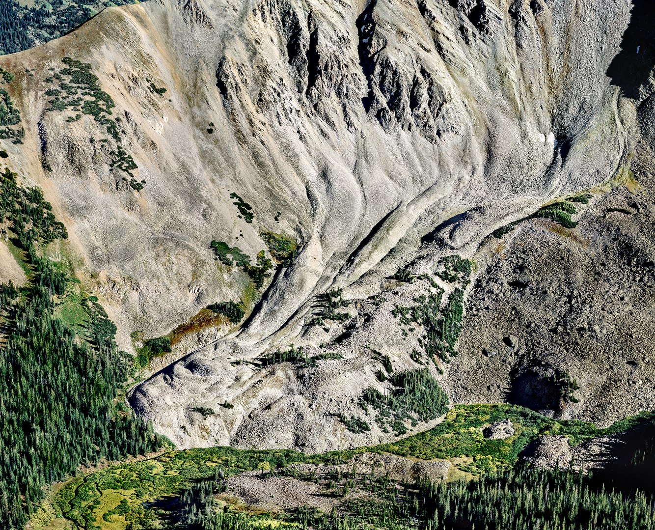
Rock Glacier, Cathedral Lake Trail, near Aspen, Colorado
When I first saw this rock glacier from the valley floor, it looked like a scree slope, flat and stationary. Further up the trail, as I photographed this scene from above, I realized its appearance was much different, exhibiting the same shape and sense of movement as an ice glacier. However, unlike the smooth exterior of ice glaciers, its furrowed surface resembled pale, desiccated skin.
Rock glaciers form in a manner similar to ice...
more
Sunlight, Morning Mist, Sitka Grove, Cape Lookout Beach, Oregon
Sitka spruce inhabited glacial moraines left from the last ice age along the Pacific coast from California to Alaska. They thrive on frequent morning fog and are unfazed by clouds of salty wave spray from onshore winds. This species welcomes the fury of late fall's blustery storms and winter's ample rains. Though the low sun of December's solstice does not penetrate the thick stands easily, the trees continuously grow from year-round...
more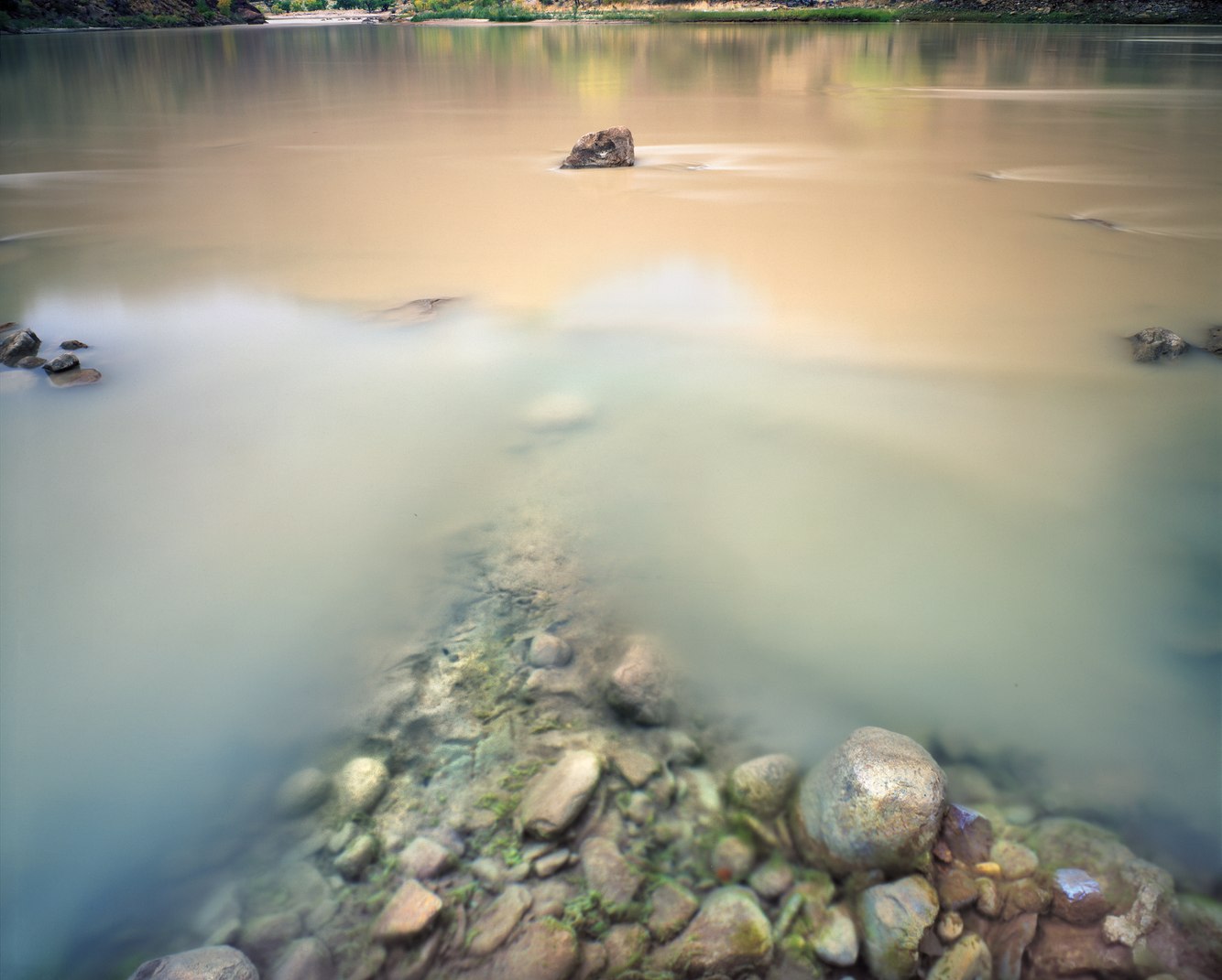
Confluence, Rock Creek and Green River, Desolation Canyon, Utah
Carved deep within the cavernous fold of a plateau bordering both sides of the Green River is a remote canyon that traverses eastern Utah’s desert. “We pass through a region of the wildest desolation,” wrote John Wesley Powell, thus naming the canyon during a historic 1869 river expedition that eventually carried him and his crew through the Grand Canyon.
Rock Creek begins at the 9800-foot crest of the Roan Cliffs, cascading down to...
more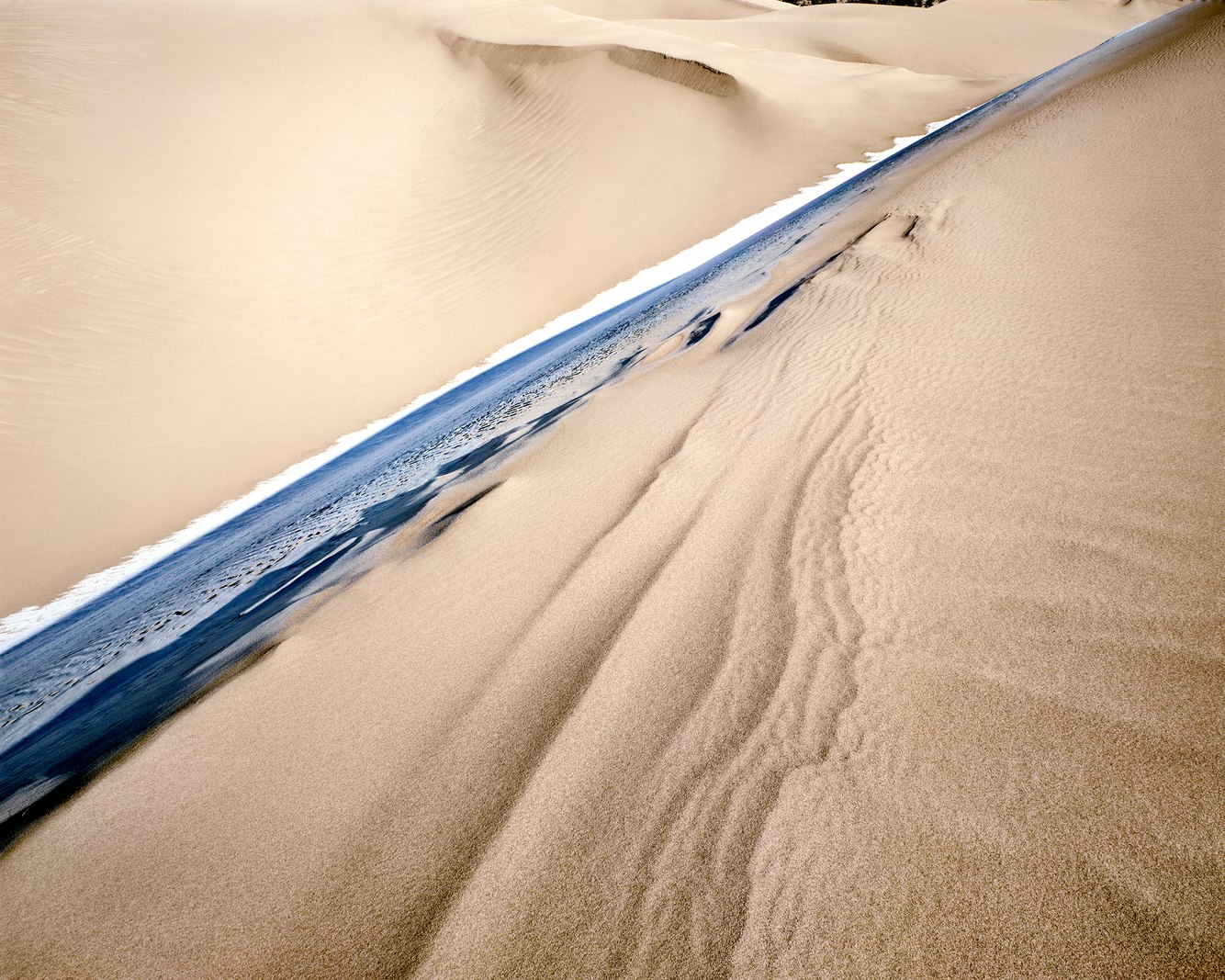
Morning Frost, Great Sand Dunes National Park, Colorado
“Their appearance was exactly that of the sea in a storm, except as to color, not the least sign of vegetation existing thereon,” wrote U.S. Army Lieutenant Zebulon Pike about the Great Sand Dunes on an 1807 expedition he led through the Rocky Mountains.
Dune fields often form where the earth’s tectonic plates move apart, creating depressions in the earth’s contours known as rift valleys, such as southern Colorado’s San Luis Valley....
more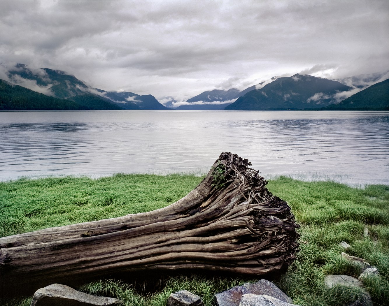
Drift Log, Skeena River, British Columbia, Canada
The Skeena River is one of North America's largest free-flowing (undammed) rivers. Its course runs from the interior of northern British Columbia to its coast, passing through the world's largest intact temperate rainforest, the Great Bear Rainforest.
To the native nations that share this region, "the word 'Skeena' means "water from cloud," a place of abundant rainfall and persistent cloud cover. Geographically, they rely on a mild...
more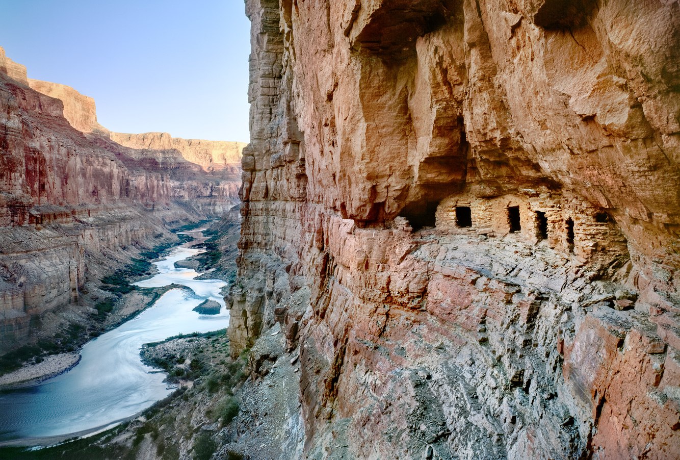
Nankoweap Granaries, Colorado River, Grand Canyon, Arizona
Granaries are storehouses for safely preserving seeds, beans, and grains away from animals, insects, disease, and floods. Typically built from timber, stone, and clay, evidence of their construction goes back over 11,000 years, and they continue to be used worldwide today.
The Nankoweap Granaries were built around 1100 AD by members of the Ancestral Puebloan culture who cultivated food in a significantly different environment. Today,...
more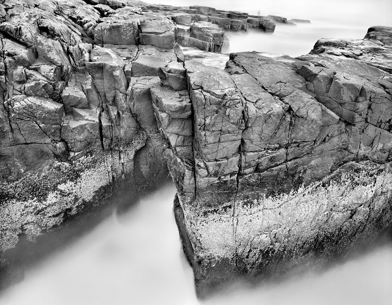
Granite Bedrock, Atlantic Ocean, Schoodic Point, Maine
Extending far seaward from Maine’s eastern coast, shifting tectonic plates and ancient erosion exposed Schoodic Point's bedrock. Granite fractured into irregular blocks, broken seams filled by molten flows that cooled into black basaltic veins.
After the last ice-age glaciers retreated, the rock shelves again rose and stabilized. Today, granite benches flank the ocean, its flat-topped terraces tilting down to the North Atlantic's edge....
more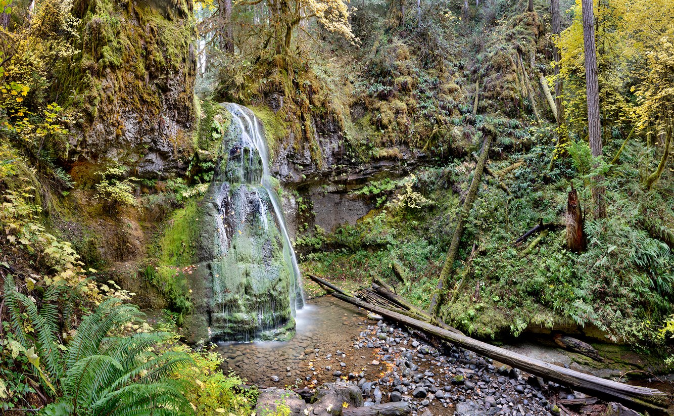
Spirit Falls, near Oakridge, Oregon
Cradled in a lava bowl, Alex Creek flows over a 40-foot moss-covered outcrop, draping it like a luminous veil as spring-fed water spills into a shallow pool. Echoing off its basaltic walls, one can hear the waterfall before it comes into view, hidden in the cleft of an old-growth forest of Douglas-fir, western hemlock, and big-leaf maple.
Spirit Falls is a dreamlike refuge between the crest of the Cascade Range and the Willamette Valley...
more
Young Engelmann Spruce, Spruce Beetle Epidemic, Hanson's Mill, near Creede, Colorado
Above the historic silver mining town of Creede, Colorado, an 11,000-foot plateau skirts the San Juan Mountains of southern Colorado. One summer day in the 1980s, I hiked from an abandoned sawmill through ancient groves of blue-green spruce. The La Garita Wilderness I entered appeared to float above the world. La Garita is Spanish for "lookout," aptly describing a wondrous panorama of snowmelt creeks deeply incised through the gentle terrain...
more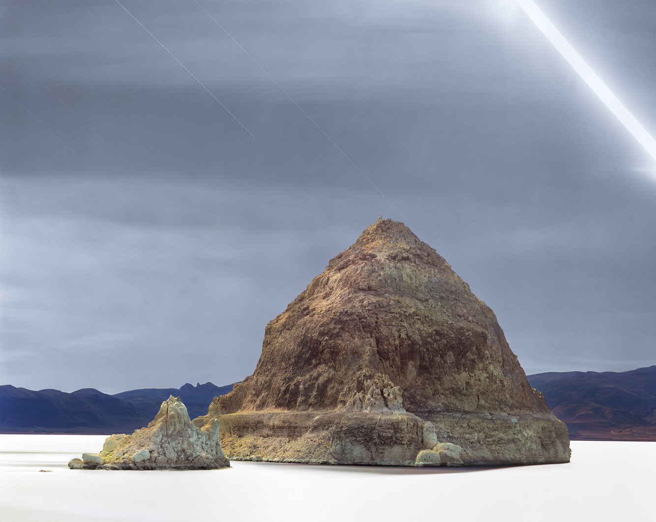
Moonlight, The Pyramid, Pyramid Lake, Nevada
The moon arched across the night sky, and from its sweeping light, this six-hour film exposure rendered a soft glow to the island and lake. The Northern Paiute call the island "Wono" – the name for their woven cone-shaped baskets. In 1843, government expedition leader John Fremont gave the island and the lake their current names when he wrote in his diary, "We encamped on the shore, opposite a very remarkable rock in the lake … from the point...
more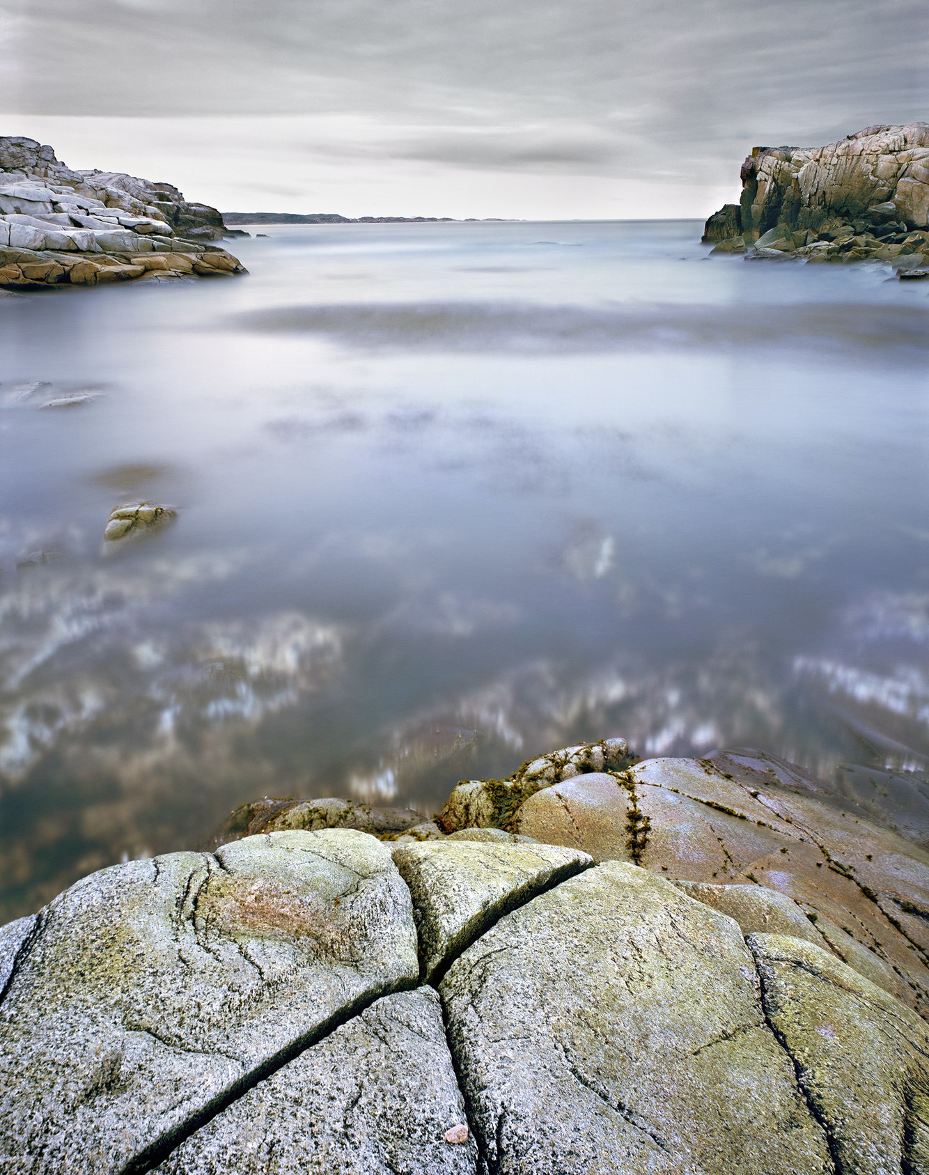
Salmon Cove, Rose Blanche, Newfoundland, Canada
Newfoundland’s rugged and exposed south coast contains numerous fjords, bays, and harbors supporting small and widely separated villages. These “outports,” only accessible by fishing boats and coastal steamers, date back to the 1500s and earlier.
Historically rich in fishing grounds, over-harvesting during the latter half of the 20th century collapsed the industry in 1992. One effect was the emigration of inhabitants from smaller...
more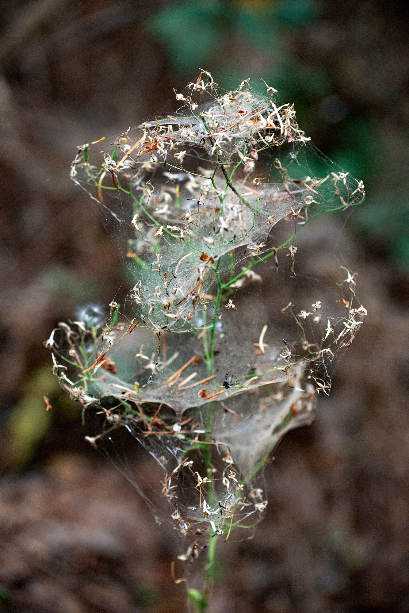
Plant Wrapped in Spider Web, Discovery Park, Seattle, Washington
Summers in western Washington State challenge the usual perception of the Pacific Northwest as a perpetually cool, wet place. The weather is warm and dry from Independence Day to Labor Day. Perfect for building spider webs so that by the end of August, they abound everywhere in the forests, including this park near Seattle.
Some plants become enveloped by cobwebs. And very different types of spiders can produce them, the smallest being...
more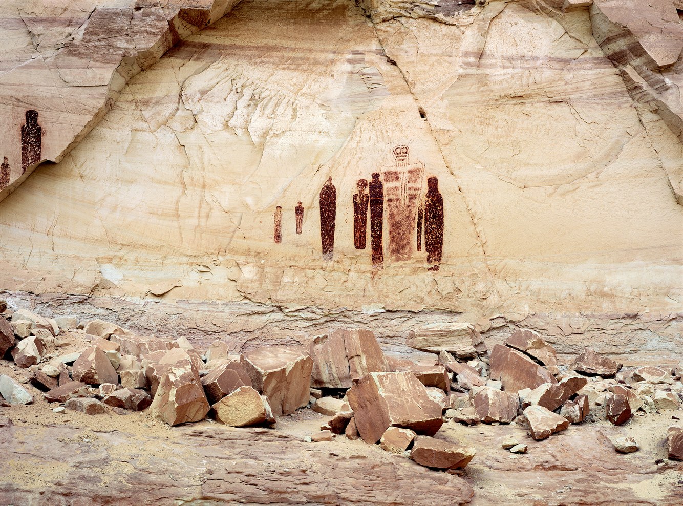
Pictographs, Holy Ghost Panel, Horseshoe Canyon, Utah
Horseshoe Canyon shelters one of North America's most significant rock art sites. Beginning around 8000 BC, hunter-gatherers from the Desert Archaic Period seasonally visited this canyon and created pictographs (paintings on rock walls) between 1000 BC and 1000 AD. Using a mixture of blood, vegetable, and mineral compounds, they depicted hundreds of figures as tall as eight feet and as small as six inches along a 200-foot wall within this...
more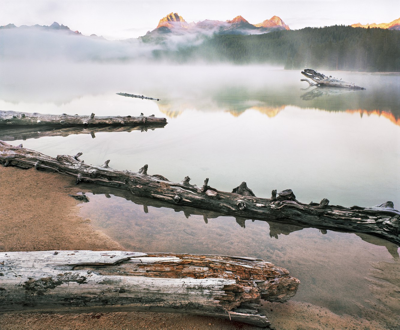
Redfish Lake, Sawtooth Mountains, Idaho
Redfish Lake is the headwater of central Idaho’s Salmon River, which flows into the Snake River and continues to the Columbia River and Pacific Ocean. Up until the late 1800s, 4,000 sockeye salmon annually returned to the lake — their birthplace, 900 miles from the ocean — to bear the next generation of sockeye. It is the longest such pilgrimage in North America.
During their run, splashing sockeye used to keep ranchers awake at night....
more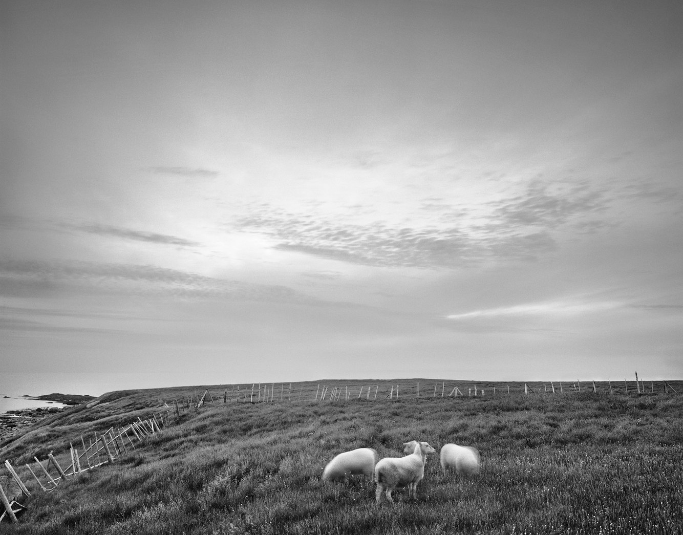
Grazing Sheep, Green Point, near Rocky Harbour, Newfoundland, Canada
Upon a wind-swept knoll above the fishing outpost of Green Point on Newfoundland’s west coast, graze a hardy strain of sheep first introduced to the island province in the 16th century. Derived from the Border Cheviot breed common to the Scottish and English borderlands, this local stock is shorn and set out to pasture in the spring and their lambs sent to market in November as the blustery winter sets in.
The field of summer forage...
more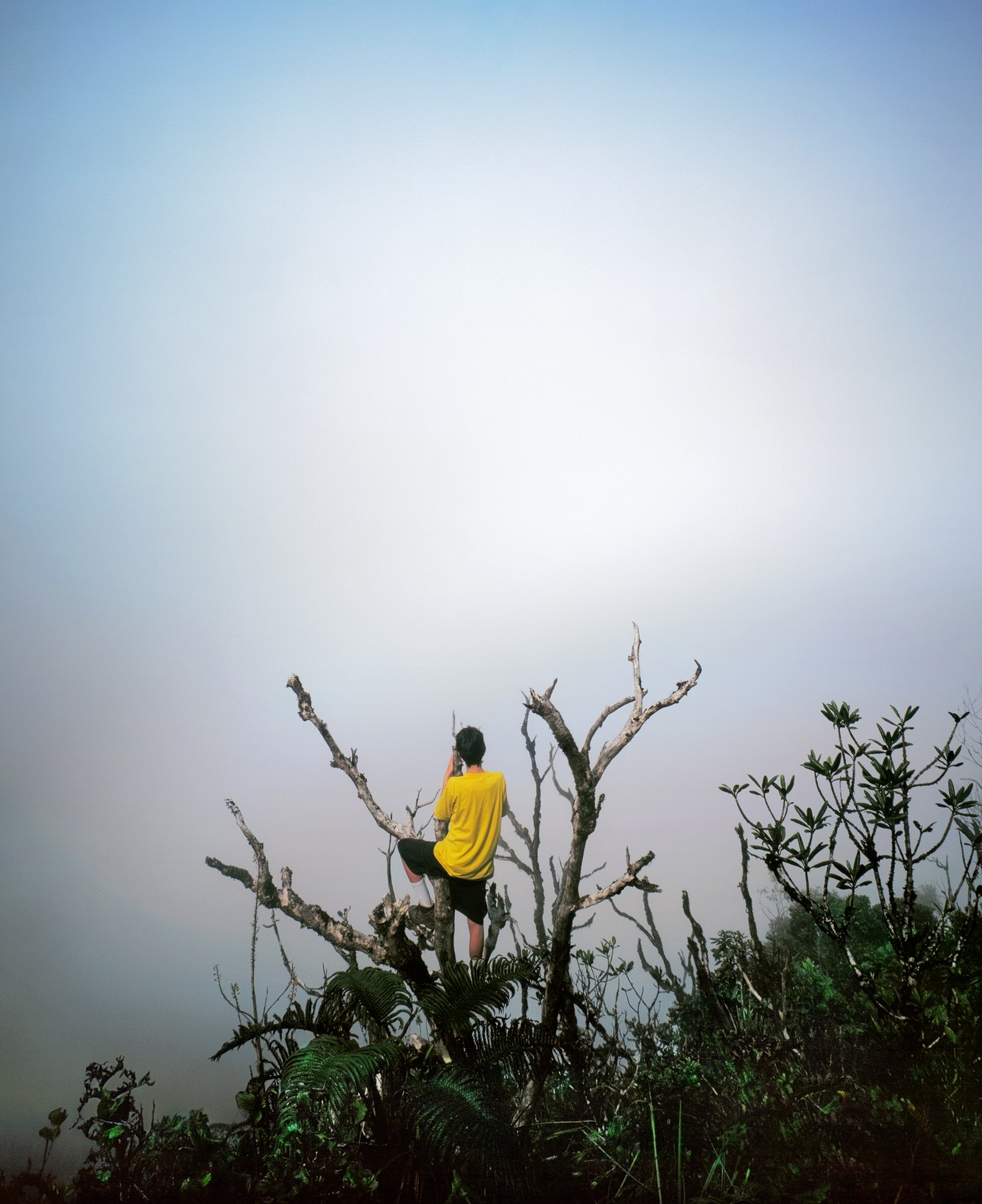
Luke, Wainiha Ridge, Kaua'i, Hawaii
Four thousand feet above the Pacific Ocean on the northwestern side of Kaua'i lies a deeply furrowed plateau, the remains of a caldera rimmed by Wainiha Ridge. Lava flows and accumulations of sediment have eroded since Kaua'i’s volcanic origins millions of years ago. In truth, this ridge is nearly 20,000 feet above the ocean floor. A relic of an ancient seamount — the oldest in the Hawaiian island chain — these highlands are covered by a...
more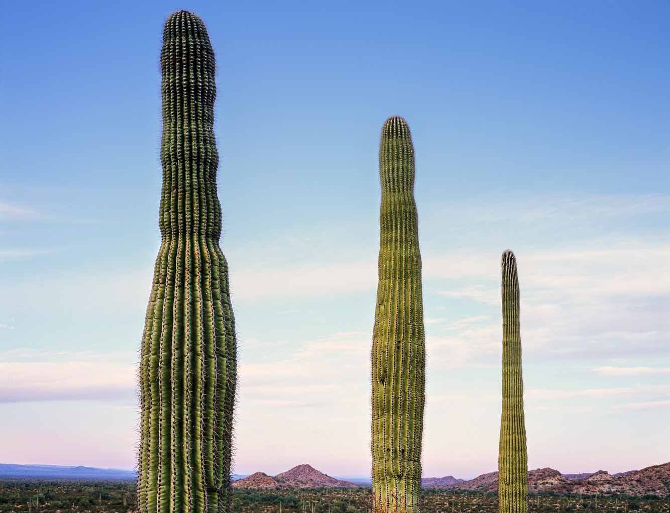
Saguaros, Crater Range, Arizona
Few other plants are so readily identified by place as the saguaro in Arizona’s Sonoran Desert. Though it looks like a tree, it is in fact a cactus. The tallest plant in this desert and largest cactus in the United States, it typically grows to 45 feet and weighs 4000 pounds. Saguaros take a century to mature and after that may live as long as another century.
The cactus’ imposing size, its arms gesturing to the sky, and the fact that...
more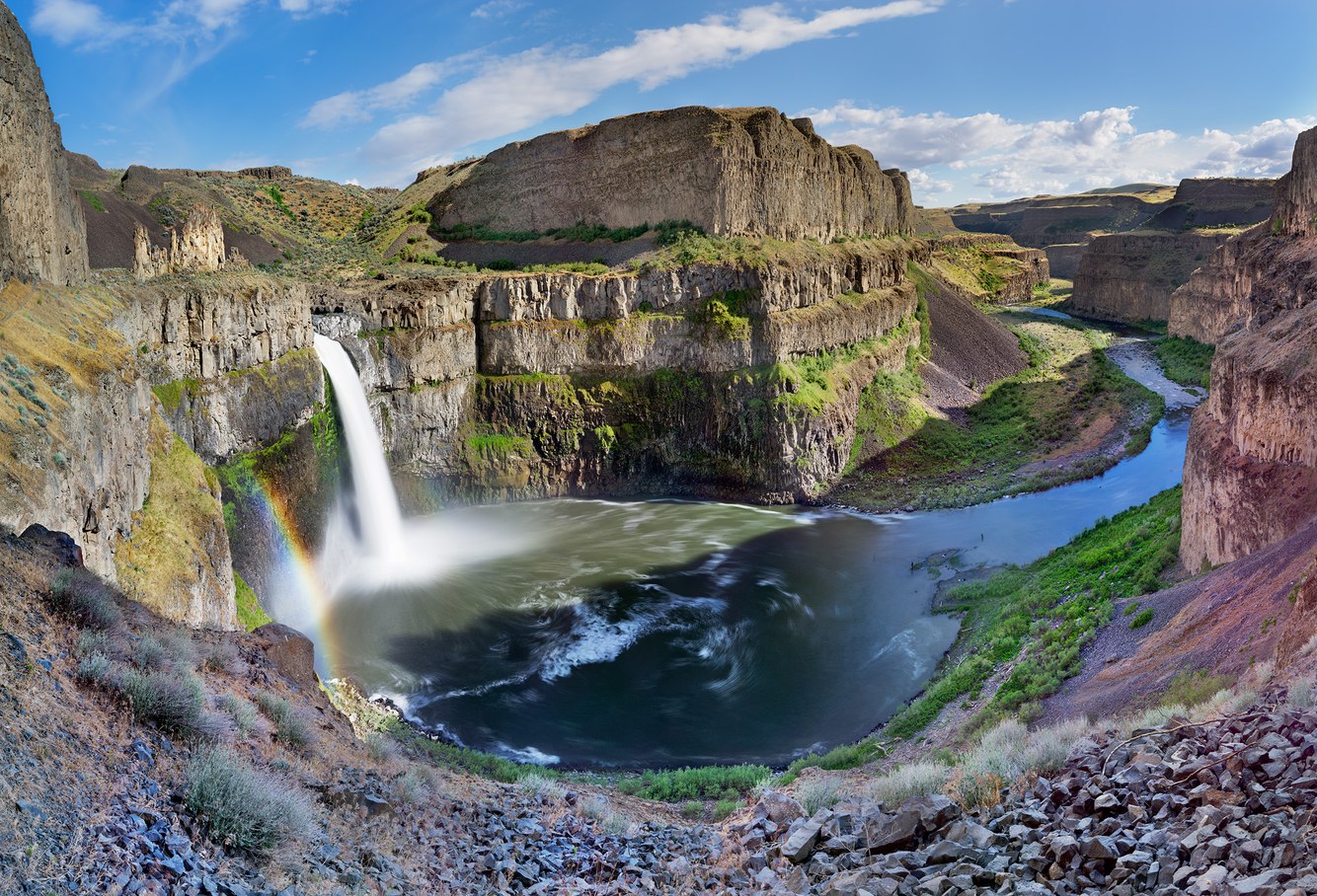
Palouse Falls, Washington
Fifteen thousand years ago, what is now western Montana, lay beneath a 2000-foot-deep lake formed from meltwaters that became impounded after exiting an ice sheet that covered large parts of North America. Twice a century for two millennia, an ice dam formed and then, under building pressure from rising water, periodically ruptured sending cataclysmic floods across parts of Idaho and Washington State into the Columbia River Gorge. Driving...
more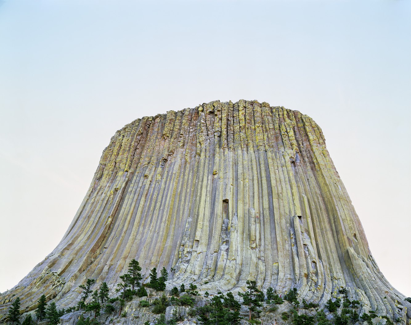
Devils Tower, above the Belle Fourche River, Wyoming
On this early dawn around summer solstice, the sun rose behind the western face of Devils Tower. The architecture of this 1300-foot structure was first formed underground from molten volcanic rock that slowly cooled from liquid into hardened polygonal columns made of rare and exceptionally durable phonolite porphyry. Long buried beneath layers of sedimentary rock, the erosion of the softer sandstone, shale and gypsum around the structure, in...
more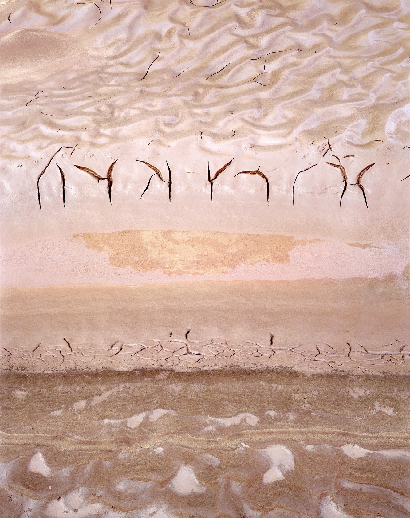
Moonlight Wash, San Juan River, Utah
A couple of days prior to making this photograph, the San Juan River that traverses southern Utah suddenly surged. Its color turned from grey-green to red. The flood’s origin was from northeastern Arizona’s reddish-brown sandstone formations. Beginning as a cloudburst, a dense muddy torrent raced down Chinle Wash entering the San Juan River at its confluence. Later, downstream in the quiet backwater of Moonlight Wash, rippling patterns of mud...
more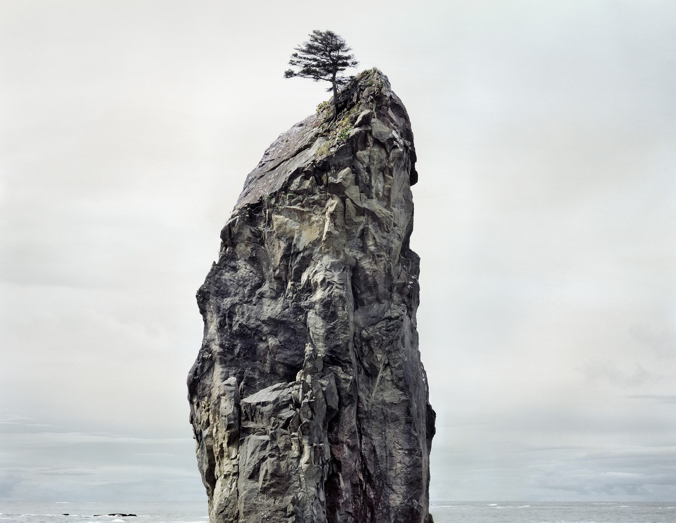
Sitka Spruce, Sea Stack, Rialto Beach, Olympic Peninsula, Washington
A lone Sitka spruce grew atop this sea stack, protected on its windward side by the crest of a 50-foot pillar that is the eroded remains of land uplifted by the movement of tectonic plates. On this spring day along Washington’s northwest shoreline, the earth was quiet and the seas calm; a 314-year reprieve from the most recent of violent earthquakes and tsunamis that shaped this region, and a seasonal break from winter’s heavy surf that...
more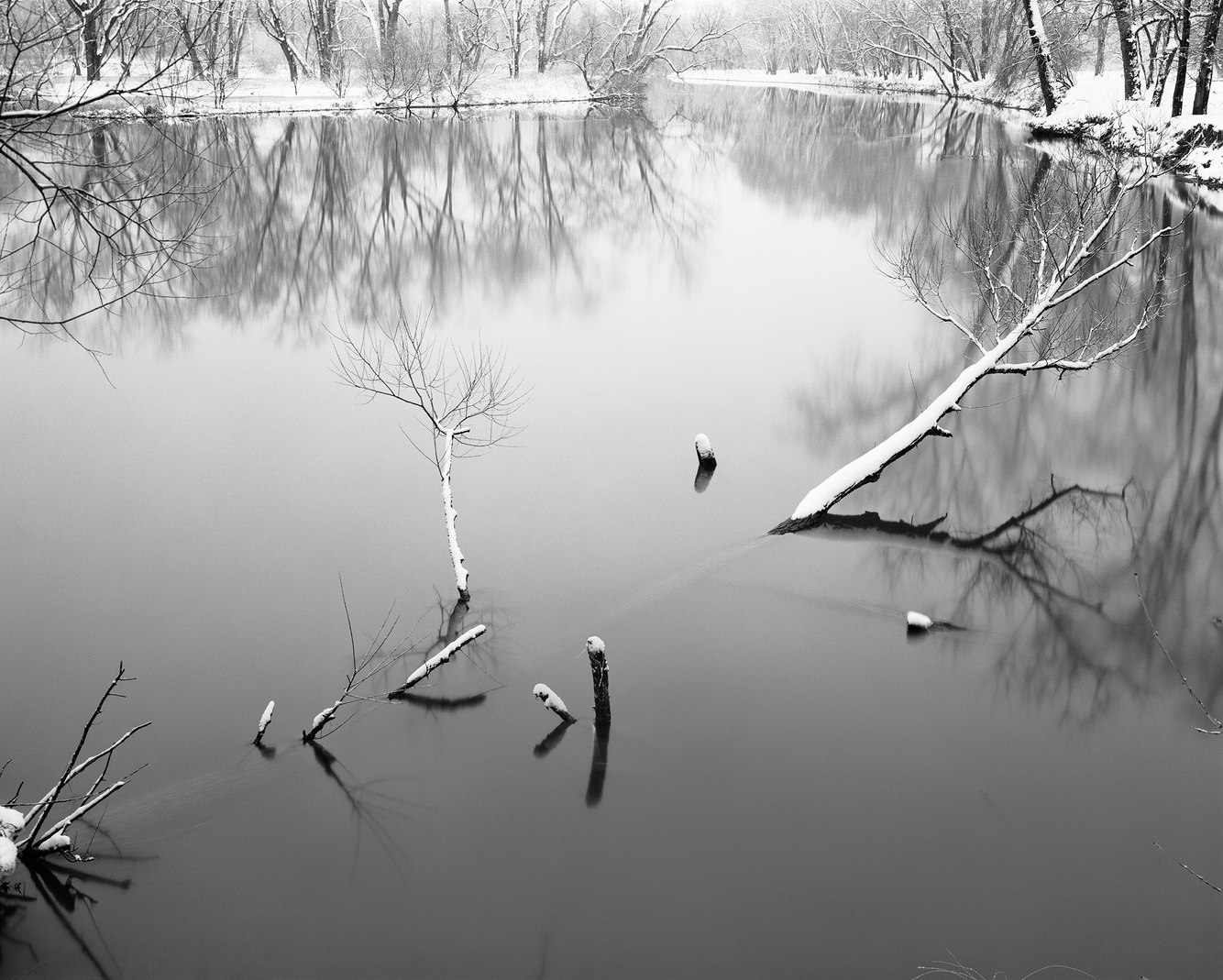
French Creek, near Cambridge Springs, Pennsylvania
Prior to the last ice age, French Creek flowed north to Lake Erie and then to the Atlantic Ocean. Later, retreating glaciers deposited a thick layer of rock debris in the northwestern corner of Pennsylvania. Its terminal moraine blocked the creek and forced it to reverse course and flow south joining the Allegheny River, which runs into the Ohio and then Mississippi River, eventually draining into the Gulf of Mexico. The creek remains one...
more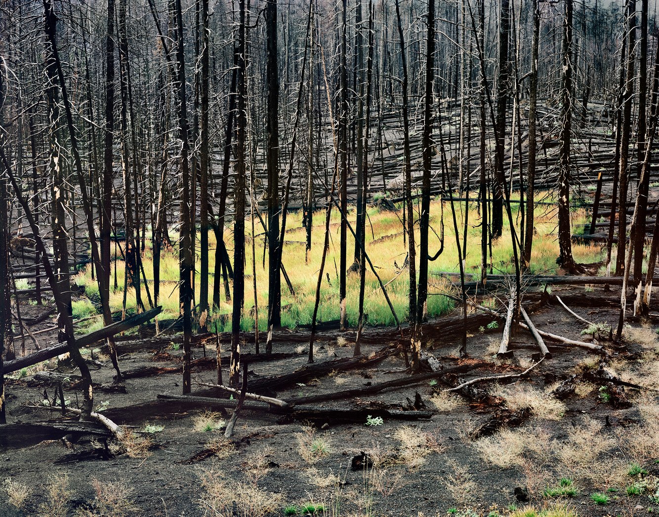
Two Years after The Fire, Yellowstone National Park, Wyoming
In 1988, a wet spring was followed by a drought that led to the driest summer in the history of Yellowstone National Park. Fueled by dry tinder, lighting, strong winds, and, to a lesser extent, the activities of outfitters and woodcutters, over 50 separate fires merged to create an out-of-control conflagration that burned 800,000 acres of the northwestern corner of Wyoming.
Dozens of elk and other animals were consumed by fire, as was...
more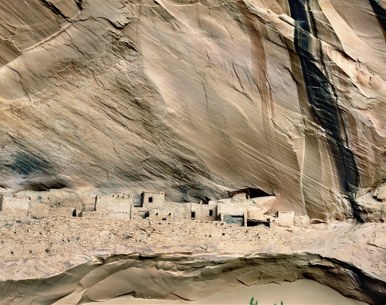
Kiet Siel, Tsegi Canyon, Arizona
Concealed deep within the canyons of northern Arizona are the remains of well-preserved dwellings sheltered beneath an overhanging cliff of Navajo Sandstone. Over the period it was inhabited, 150 living spaces and granaries were built on a ledge high above the canyon floor, securing the community from enemies and inclement weather. At first glance, it’s difficult to distinguish the village from the alcove within which it sits; its...
more
Gulf of St Lawrence from Cap Rouge, Cape Breton Island, Canada
Along Nova Scotia’s northwest coast, the steep slopes of Cap-Rouge’s French Mountain meet the southern shore of the Gulf of St. Lawrence. An extension of the Appalachian Mountain chain; Cape Breton’s tablelands are built upon the most ancient known rocks in Canada’s Maritime Provinces.
Skirting its coastline, in 1932 the once rocky Cabot Trail was replaced by a paved scenic highway encircling the cape. Beginning in the early 19th...
more
Scrub Oak and Piñon, Castle Valley, Utah
During late September, as nights lengthen and scrub oaks lose their chlorophyll, their leaves turn to rich hues of yellow, red and brown lending a surreal aspect to this austere desert. Cradled within the northern slopes of Utah’s rugged La Sal Mountains, Castle Valley is an unexpectedly level basin. Three hundred million years ago, this place was along a shoreline that built up thick layers of salt later buried beneath heavy deposits of...
more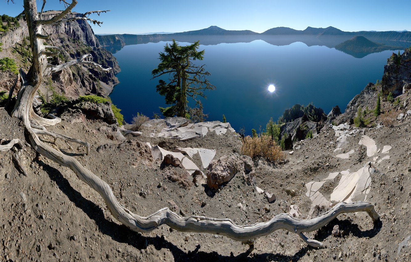
Whitebark Pine Root, Merriam Point, Crater Lake, Oregon
Seven thousand, seven hundred years ago, southwestern Oregon’s 11,000-foot Mt. Mazama erupted. Legends from the Klamath people carry first-hand accounts of the collapse of the mountain, laying waste to much of the surrounding area, depositing a deep layer of volcanic ash and, in its aftermath, creating within its volcanic caldera a 2000-foot-deep lake of pristine clarity. In this early morning of late fall, the low morning sun reflects off...
more