
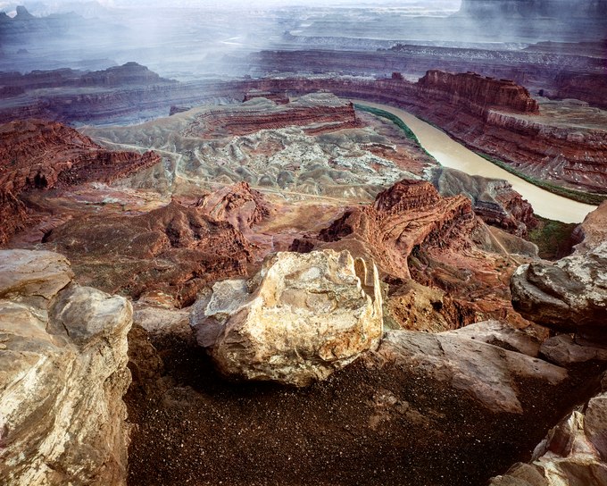
Standing at the edge of eastern Utah's Dead Horse Point, I survey a 270-degree view east, south, and west across the grand expanse of red rock country and down 2000 feet through geologic time, and the lithified layers of mud and sand from an ancient era, when the North American continent was located near the equator.
Over eons, these sedimentary stratums were deposited in oceans, windblown deserts, freshwater lakes, streams, and floodplains. Plate tectonics moved the continent north and lifted the terrain in this part of the Intermountain West, creating a high plateau. Hardened into rock and cut through by the Colorado River, today they've become rust-colored pages of a geologic book, the text block and fore-edge of each page, seen from the plateau's rim down to the river.
In the late 1800s, the narrow neck of this point was fenced off and used to corral wild mustangs that were then shipped to Kansas City to serve as workhorses for midwestern farmers. After grading and culling the herds, the less desirable horses were left behind on the point, the cowboys leaving the gate open, allowing the horses to roam free. However, sometime later, the gate was discovered closed, having left the trapped horses peering helplessly into the crevasse with its river below, eventually dying of dehydration.
Taking this photograph, I carelessly danced along the rim as an end-of-day thundershower drifted south. Caught by the euphoric drama of this vista, I recalled Edward Abbey writing about the lofty perspective along the edge of this plateau: "…we are standing on one of the frontiers of human culture…it was land's end, the shore of the world."
- James Baker